Okino-Klyuchi geodata
Okino-Klyuchi (Buryatiya Republic) is a populated place; located in Russia in Asia/Irkutsk (GMT+8) time zone. With population of 1,100 people, there are 4575 cities with bigger population in this country. Compared to other cities in Russia, 76.4% of cities are located further ↑North; 90.3% of cities are located further ←West and 94.5% of cities have lower elevation than Okino-Klyuchi. Note1


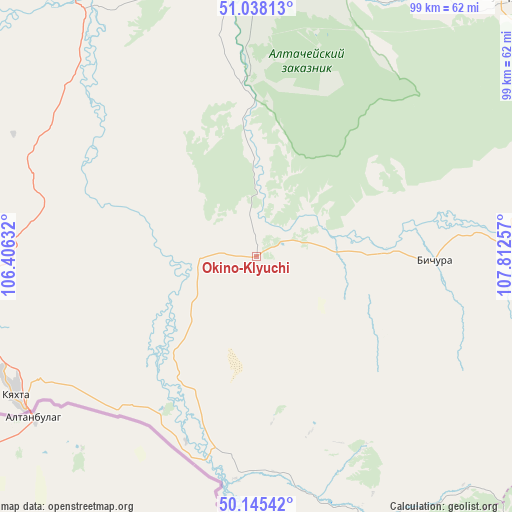
Okino-Klyuchi GPS coordinates[2]
50° 35' 38.004" North, 107° 6' 33.984" East
| Map corner | latitude | longitude |
|---|---|---|
| Upper-left | 51.03813°, | 106.40632° |
| Center: | 50.59389°, | 107.10944° |
| Lower-right: | 50.14542°, | 107.81257° |
| Map W x H: | 99.3×99.3 km | = 61.7×61.7mi |
| max Lat: | 73.50819° ⇑76.4% North |
| Okino-Klyuchi: | 50.59389° |
| min Lat: | ⇓23.6% South 41.28413° |
| min Long | Okino-Klyuchi | max Long |
| -179.12198° | 107.10944° | 179.35046° |
| W 90.3%⇐ | ⇒9.7% E |
Elevation
Elevation of Okino-Klyuchi is 606 m = 1988 ft, and this is 403.4 m = 1323 ft above average elevation for this country.
| Max E: |
2518 m = 8261 ft | 5.5% |
| Okino-Klyuchi | 606 m 1988 ft | |
| Avg. | 202.6 m = 665 ft | |
Min E: |
-28 m = -92 ft | 94.5% |
See also: Russia elevation on elevation.city.
Geographical zone
Okino-Klyuchi is located in North temperate zone (between Tropic of Cancer and the Arctic Circle). Distance of this North polar circle is 1775.7 km =1103.4 mi to North.| Distance of | km | miles | from Okino-Klyuchi |
|---|---|---|---|
| North Pole | 4381.5 | 2722.5 | to North |
| Arctic Circle | 1775.7 | 1103.4 | to North |
| Tropic Cancer | 3019.6 | 1876.3 | to South |
| Equator | 5625.5 | 3495.5 | to South |


Nearby cities:
15 places around Okino-Klyuchi: (largest is in red/bold)
• Bichura
34.8 km =21.6 mi,  91°
91°
• Chikoy
38.9 km =24.2 mi,  200°
200°
• Dzhida
66.2 km =41.1 mi,  278°
278°
• Gashey
52.8 km =32.8 mi,  20°
20°
• Gusinoozyorsk
87.7 km =54.5 mi,  330°
330°
• Gusinoye Ozero
83 km =51.6 mi,  314°
314°
• Khonkholoy
98.5 km =61.2 mi,  52°
52°
• Kudara-Somon
53 km =32.9 mi,  157°
157°
• Kyakhta
53.5 km =33.2 mi,  240°
240°
• Mukhorshibir’
71.6 km =44.5 mi,  44°
44°
• Naushki
74.8 km =46.5 mi,  251°
251°
• Novosretenka
43 km =26.7 mi,  71°
71°
• Novyy Zagan
66.7 km =41.4 mi, 43°
• Selenduma
70.7 km =43.9 mi,  300°
300°
• Sharalday
61 km =37.9 mi, 38°
Sources, notices
• [Note1] Compared only with cities in Russia existing in our database
• [Src1] Map data: © OpenStreetMap contributors (CC-BY-SA)
• [Src2] Other city data from geonames.org with taken over terms of usage.
• [Src3] Geographical zone / Annual Mean Temperature by Robert A. Rohde @ Wikipedia
