Chkalovskoye geodata
Chkalovskoye (Primorskiy (Maritime) Kray) is a populated place; located in Russia in Asia/Vladivostok (GMT+10) time zone. With population of 3,606 people, there are 3331 cities with bigger population in this country. Compared to other cities in Russia, 88.1% of cities are located further ↑North; 96.1% of cities are located further ←West and 74% of cities have higher elevation than Chkalovskoye. Note1


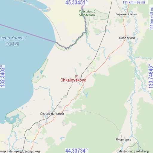
Chkalovskoye GPS coordinates[2]
44° 50' 17.088" North, 133° 2' 35.952" East
| Map corner | latitude | longitude |
|---|---|---|
| Upper-left | 45.33451°, | 132.3402° |
| Center: | 44.83808°, | 133.04332° |
| Lower-right: | 44.33734°, | 133.74645° |
| Map W x H: | 110.9×110.9 km | = 68.9×68.9mi |
| max Lat: | 73.50819° ⇑88.1% North |
| Chkalovskoye: | 44.83808° |
| min Lat: | ⇓11.9% South 41.28413° |
| min Long | Chkalovskoye | max Long |
| -179.12198° | 133.04332° | 179.35046° |
| W 96.1%⇐ | ⇒3.9% E |
Elevation
Elevation of Chkalovskoye is 91 m = 299 ft, and this is 111.6 m = 366 ft below average elevation for this country.
| Max E: |
2518 m = 8261 ft | 74% |
| Avg. | 202.6 m = 665 ft | |
| Chkalovskoye | 91 m = 299 ft | |
Min E: |
-28 m = -92 ft | 26% |
See also: Russia elevation on elevation.city.
Geographical zone
Chkalovskoye is located in North temperate zone (between Tropic of Cancer and the Arctic Circle). Distance of this Northern Tropic circle is 2379.6 km =1478.6 mi to South.| Distance of | km | miles | from Chkalovskoye |
|---|---|---|---|
| North Pole | 5021.5 | 3120.2 | to North |
| Arctic Circle | 2415.6 | 1501 | to North |
| Tropic Cancer | 2379.6 | 1478.6 | to South |
| Equator | 4985.5 | 3097.8 | to South |


Nearby cities:
15 places around Chkalovskoye: (largest is in red/bold)
• Arsen’yev
78.5 km =48.8 mi,  166°
166°
• Chernigovka
66.7 km =41.4 mi,  214°
214°
• Chernyshëvka
71.3 km =44.3 mi, 174°
• Dostoyevka
66.7 km =41.4 mi,  148°
148°
• Gornyye Klyuchi
57.8 km =35.9 mi,  38°
38°
• Grazhdanka
69.9 km =43.4 mi, 171°
• Kamen’-Rybolov
79.3 km =49.3 mi,  262°
262°
• Kirovskiy
45.8 km =28.5 mi,  51°
51°
• Lesozavodsk
77.4 km =48.1 mi,  22°
22°
• Novosysoyevka
71.7 km =44.6 mi,  159°
159°
• Rettikhovka
77.3 km =48 mi,  196°
196°
• Sivakovka
66.8 km =41.5 mi,  233°
233°
• Spassk-Dal’niy
31.7 km =19.7 mi, 212°
• Spasskoye
31.6 km =19.6 mi,  217°
217°
• Yakovlevka
57.1 km =35.5 mi,  143°
143°
Sources, notices
• [Note1] Compared only with cities in Russia existing in our database
• [Src1] Map data: © OpenStreetMap contributors (CC-BY-SA)
• [Src2] Other city data from geonames.org with taken over terms of usage.
• [Src3] Geographical zone / Annual Mean Temperature by Robert A. Rohde @ Wikipedia
