Yakovlevka geodata
Yakovlevka (Primorskiy (Maritime) Kray) is a populated place; located in Russia in Asia/Vladivostok (GMT+10) time zone. With population of 4,996 people, there are 2670 cities with bigger population in this country. Compared to other cities in Russia, 89.6% of cities are located further ↑North; 96.4% of cities are located further ←West and 51.6% of cities have higher elevation than Yakovlevka. Note1


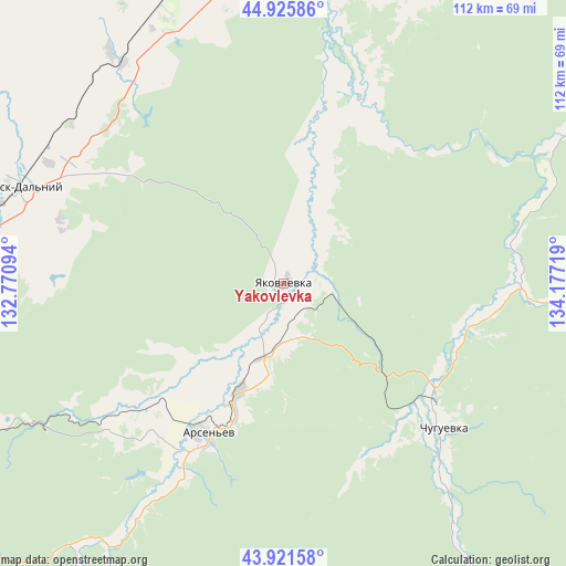
Yakovlevka GPS coordinates[2]
44° 25' 33.168" North, 133° 28' 26.616" East
| Map corner | latitude | longitude |
|---|---|---|
| Upper-left | 44.92586°, | 132.77094° |
| Center: | 44.42588°, | 133.47406° |
| Lower-right: | 43.92158°, | 134.17719° |
| Map W x H: | 111.7×111.7 km | = 69.4×69.4mi |
| max Lat: | 73.50819° ⇑89.6% North |
| Yakovlevka: | 44.42588° |
| min Lat: | ⇓10.4% South 41.28413° |
| min Long | Yakovlevka | max Long |
| -179.12198° | 133.47406° | 179.35046° |
| W 96.4%⇐ | ⇒3.6% E |
Elevation
Elevation of Yakovlevka is 141 m = 463 ft, and this is 61.6 m = 202 ft below average elevation for this country.
| Max E: |
2518 m = 8261 ft | 51.6% |
| Avg. | 202.6 m = 665 ft | |
| Yakovlevka | 141 m = 463 ft | |
Min E: |
-28 m = -92 ft | 48.4% |
See also: Russia elevation on elevation.city.
Geographical zone
Yakovlevka is located in North temperate zone (between Tropic of Cancer and the Arctic Circle). Distance of this Northern Tropic circle is 2333.8 km =1450.2 mi to South.| Distance of | km | miles | from Yakovlevka |
|---|---|---|---|
| North Pole | 5067.4 | 3148.7 | to North |
| Arctic Circle | 2461.5 | 1529.5 | to North |
| Tropic Cancer | 2333.8 | 1450.2 | to South |
| Equator | 4939.7 | 3069.4 | to South |


Nearby cities:
15 places around Yakovlevka: (largest is in red/bold)
• Anuchino
61 km =37.9 mi,  212°
212°
• Arsen’yev
34.2 km =21.3 mi, 207°
• Chernigovka
72.5 km =45 mi,  262°
262°
• Chernyshëvka
37.1 km =23.1 mi,  227°
227°
• Chkalovskoye
57.1 km =35.5 mi,  323°
323°
• Chuguyevka
42.4 km =26.3 mi,  132°
132°
• Dostoyevka
11.2 km =7 mi,  177°
177°
• Grazhdanka
33.2 km =20.6 mi, 225°
• Kirovskiy
74.2 km =46.1 mi,  1°
1°
• Monastyrishche
81.4 km =50.6 mi,  251°
251°
• Novosysoyevka
23 km =14.3 mi,  202°
202°
• Rettikhovka
62.8 km =39 mi,  243°
243°
• Sivakovka
88 km =54.7 mi,  273°
273°
• Spassk-Dal’niy
54.9 km =34.1 mi,  290°
290°
• Spasskoye
57.3 km =35.6 mi, 291°
Sources, notices
• [Note1] Compared only with cities in Russia existing in our database
• [Src1] Map data: © OpenStreetMap contributors (CC-BY-SA)
• [Src2] Other city data from geonames.org with taken over terms of usage.
• [Src3] Geographical zone / Annual Mean Temperature by Robert A. Rohde @ Wikipedia
