Spassk-Dal’niy geodata
Spassk-Dal’niy (Primorskiy (Maritime) Kray) is a populated place; located in Russia in Asia/Vladivostok (GMT+10) time zone. With population of 45,265 people, there are 464 cities with bigger population in this country. Compared to other cities in Russia, 89.2% of cities are located further ↑North; 96% of cities are located further ←West and 68.8% of cities have higher elevation than Spassk-Dal’niy. Note1


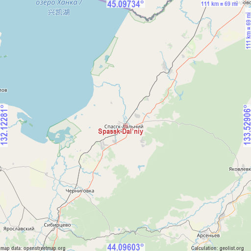
Spassk-Dal’niy GPS coordinates[2]
44° 35' 55.824" North, 132° 49' 33.348" East
| Map corner | latitude | longitude |
|---|---|---|
| Upper-left | 45.09734°, | 132.12281° |
| Center: | 44.59884°, | 132.82593° |
| Lower-right: | 44.09603°, | 133.52906° |
| Map W x H: | 111.3×111.3 km | = 69.2×69.2mi |
| max Lat: | 73.50819° ⇑89.2% North |
| Spassk-Dal’niy: | 44.59884° |
| min Lat: | ⇓10.8% South 41.28413° |
| min Long | Spassk-Dal’ni | max Long |
| -179.12198° | 132.82593° | 179.35046° |
| W 96%⇐ | ⇒4% E |
Elevation
Elevation of Spassk-Dal’niy is 105 m = 344 ft, and this is 97.6 m = 320 ft below average elevation for this country.
| Max E: |
2518 m = 8261 ft | 68.8% |
| Avg. | 202.6 m = 665 ft | |
| Spassk-Dal’niy | 105 m = 344 ft | |
Min E: |
-28 m = -92 ft | 31.2% |
See also: Spassk-Dal’niy elevation on elevation.city.
Geographical zone
Spassk-Dal’niy is located in North temperate zone (between Tropic of Cancer and the Arctic Circle). Distance of this Northern Tropic circle is 2353 km =1462.1 mi to South.| Distance of | km | miles | from Spassk-Dal’niy |
|---|---|---|---|
| North Pole | 5048.1 | 3136.7 | to North |
| Arctic Circle | 2442.2 | 1517.5 | to North |
| Tropic Cancer | 2353 | 1462.1 | to South |
| Equator | 4958.9 | 3081.3 | to South |


Nearby cities:
15 places around Spassk-Dal’niy: (largest is in red/bold)
• Arsen’yev
61.3 km =38.1 mi,  144°
144°
• Chernigovka
35.1 km =21.8 mi,  215°
215°
• Chernyshëvka
50.6 km =31.4 mi,  151°
151°
• Chkalovskoye
31.7 km =19.7 mi,  32°
32°
• Dostoyevka
60.2 km =37.4 mi,  120°
120°
• Grazhdanka
50.9 km =31.6 mi, 146°
• Kamen’-Rybolov
63.7 km =39.6 mi,  284°
284°
• Khorol’
62.5 km =38.8 mi,  252°
252°
• Luchki
56.8 km =35.3 mi,  232°
232°
• Monastyrishche
51.6 km =32.1 mi,  209°
209°
• Novosysoyevka
58.9 km =36.6 mi,  133°
133°
• Rettikhovka
47.8 km =29.7 mi,  185°
185°
• Sivakovka
38.7 km =24 mi, 249°
• Spasskoye
2.5 km =1.6 mi,  305°
305°
• Yakovlevka
54.9 km =34.1 mi,  110°
110°
Sources, notices
• [Note1] Compared only with cities in Russia existing in our database
• [Src1] Map data: © OpenStreetMap contributors (CC-BY-SA)
• [Src2] Other city data from geonames.org with taken over terms of usage.
• [Src3] Geographical zone / Annual Mean Temperature by Robert A. Rohde @ Wikipedia
