Nikolayevsk-on-Amure geodata
Nikolayevsk-on-Amure (Khabarovsk) is a populated place; located in Russia in Asia/Vladivostok (GMT+10) time zone. With population of 27,152 people, there are 716 cities with bigger population in this country. Compared to other cities in Russia, 61.9% of cities are located further ↑North; 97.9% of cities are located further ←West and 87% of cities have higher elevation than Nikolayevsk-on-Amure. Note1


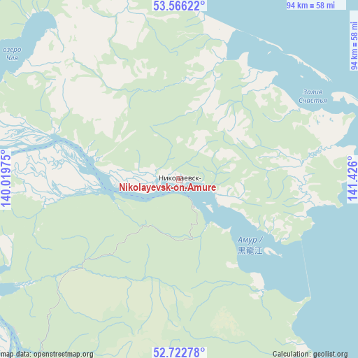
Nikolayevsk-on-Amure GPS coordinates[2]
53° 8' 47.652" North, 140° 43' 22.332" East
| Map corner | latitude | longitude |
|---|---|---|
| Upper-left | 53.56622°, | 140.01975° |
| Center: | 53.14657°, | 140.72287° |
| Lower-right: | 52.72278°, | 141.426° |
| Map W x H: | 93.8×93.8 km | = 58.3×58.3mi |
| max Lat: | 73.50819° ⇑61.9% North |
| Nikolayevsk-on-Amure: | 53.14657° |
| min Lat: | ⇓38.1% South 41.28413° |
| min Long | Nikolayevsk-on- | max Long |
| -179.12198° | 140.72287° | 179.35046° |
| W 97.9%⇐ | ⇒2.1% E |
Elevation
Elevation of Nikolayevsk-on-Amure is 40 m = 131 ft, and this is 162.6 m = 533 ft below average elevation for this country.
| Max E: |
2518 m = 8261 ft | 87% |
| Avg. | 202.6 m = 665 ft | |
| Nikolayevsk-on-Amure | 40 m = 131 ft | |
Min E: |
-28 m = -92 ft | 13% |
See also: Russia elevation on elevation.city.
Geographical zone
Nikolayevsk-on-Amure is located in North temperate zone (between Tropic of Cancer and the Arctic Circle). Distance of this North polar circle is 1491.8 km =927 mi to North.| Distance of | km | miles | from Nikolayevsk-on-Amure |
|---|---|---|---|
| North Pole | 4097.7 | 2546.2 | to North |
| Arctic Circle | 1491.8 | 927 | to North |
| Tropic Cancer | 3303.4 | 2052.6 | to South |
| Equator | 5909.3 | 3671.9 | to South |


Nearby cities:
15 places around Nikolayevsk-on-Amure: (largest is in red/bold)
• Aleksandrovsk-Sakhalinskiy
268.6 km =166.9 mi,  158°
158°
• Bogorodskoye
88 km =54.7 mi,  192°
192°
• De-Kastri
185.8 km =115.5 mi,  179°
179°
• Ekhabi
154.5 km =96 mi,  74°
74°
• Katangli
232.4 km =144.4 mi,  133°
133°
• Lazarev
115.7 km =71.9 mi,  152°
152°
• Mago
38.1 km =23.7 mi,  289°
289°
• Mgachi
256.1 km =159.1 mi, 155°
• Mnogovershinnyy
102.1 km =63.4 mi,  329°
329°
• Nogliki
221.8 km =137.8 mi, 132°
• Okha
156 km =96.9 mi, 71°
• Tsimmermanovka
224.4 km =139.4 mi,  206°
206°
• Tungor
151.1 km =93.9 mi,  79°
79°
• Tymovskoye
287.9 km =178.9 mi, 152°
• Val
181.4 km =112.7 mi,  119°
119°
In other languages:
- In France: Nikolaïevsk-sur-l'Amour
- In Italian: Nikolaevsk-na-Amur
- In Russian: Николаевск-на-Амуре
Sources, notices
• [Note1] Compared only with cities in Russia existing in our database
• [Src1] Map data: © OpenStreetMap contributors (CC-BY-SA)
• [Src2] Other city data from geonames.org with taken over terms of usage.
• [Src3] Geographical zone / Annual Mean Temperature by Robert A. Rohde @ Wikipedia
