Logovskoye geodata
Logovskoye (Altai Krai) is a populated place; located in Russia in Asia/Barnaul (GMT+7) time zone. With population of 1,473 people, there are 4400 cities with bigger population in this country. Compared to other cities in Russia, 58.8% of cities are located further ↑North; 81.6% of cities are located further ←West and 71.7% of cities have lower elevation than Logovskoye. Note1


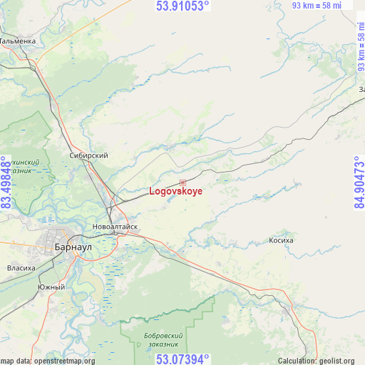
Logovskoye GPS coordinates[2]
53° 29' 39.48" North, 84° 12' 5.76" East
| Map corner | latitude | longitude |
|---|---|---|
| Upper-left | 53.91053°, | 83.49848° |
| Center: | 53.4943°, | 84.2016° |
| Lower-right: | 53.07394°, | 84.90473° |
| Map W x H: | 93×93 km | = 57.8×57.8mi |
| max Lat: | 73.50819° ⇑58.8% North |
| Logovskoye: | 53.4943° |
| min Lat: | ⇓41.2% South 41.28413° |
| min Long | Logovskoye | max Long |
| -179.12198° | 84.2016° | 179.35046° |
| W 81.6%⇐ | ⇒18.4% E |
Elevation
Elevation of Logovskoye is 203 m = 666 ft, and this is 0.40000000000001 m = 1 ft above average elevation for this country.
| Max E: |
2518 m = 8261 ft | 28.3% |
| Logovskoye | 203 m 666 ft | |
| Avg. | 202.6 m = 665 ft | |
Min E: |
-28 m = -92 ft | 71.7% |
See also: Russia elevation on elevation.city.
Geographical zone
Logovskoye is located in North temperate zone (between Tropic of Cancer and the Arctic Circle). Distance of this North polar circle is 1453.2 km =903 mi to North.| Distance of | km | miles | from Logovskoye |
|---|---|---|---|
| North Pole | 4059.1 | 2522.2 | to North |
| Arctic Circle | 1453.2 | 903 | to North |
| Tropic Cancer | 3342.1 | 2076.7 | to South |
| Equator | 5948 | 3695.9 | to South |


Nearby cities:
15 places around Logovskoye: (largest is in red/bold)
• Barnaul
32.6 km =20.3 mi,  242°
242°
• Bayunovskiye Klyuchi
18.5 km =11.5 mi,  183°
183°
• Beloyarsk
20.4 km =12.7 mi,  254°
254°
• Bobrovka
40.7 km =25.3 mi,  212°
212°
• Borovikha
24.1 km =15 mi,  273°
273°
• Firsovo
25.6 km =15.9 mi,  219°
219°
• Kosikha
29.2 km =18.1 mi,  120°
120°
• Lesnoy
32 km =19.9 mi, 208°
• Nalobikha
42 km =26.1 mi,  140°
140°
• Novoaltaysk
20.9 km =13 mi, 237°
• Pervomayskoye
28 km =17.4 mi,  334°
334°
• Sannikovo
22.4 km =13.9 mi, 222°
• Sibirskiy
30.8 km =19.1 mi,  287°
287°
• Zaton
34.4 km =21.4 mi,  229°
229°
• Zudilovo
20.4 km =12.7 mi, 269°
Sources, notices
• [Note1] Compared only with cities in Russia existing in our database
• [Src1] Map data: © OpenStreetMap contributors (CC-BY-SA)
• [Src2] Other city data from geonames.org with taken over terms of usage.
• [Src3] Geographical zone / Annual Mean Temperature by Robert A. Rohde @ Wikipedia
