Novoaltaysk geodata
Novoaltaysk (Altai Krai) is a populated place; located in Russia in Asia/Barnaul (GMT+7) time zone. With population of 61,050 people, there are 343 cities with bigger population in this country. Compared to other cities in Russia, 59.5% of cities are located further ↑North; 81.4% of cities are located further ←West and 51.1% of cities have lower elevation than Novoaltaysk. Note1


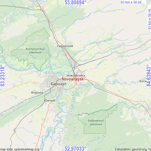
Novoaltaysk GPS coordinates[2]
53° 23' 30.12" North, 83° 56' 10.68" East
| Map corner | latitude | longitude |
|---|---|---|
| Upper-left | 53.80894°, | 83.23318° |
| Center: | 53.3917°, | 83.9363° |
| Lower-right: | 52.97033°, | 84.63943° |
| Map W x H: | 93.2×93.2 km | = 57.9×57.9mi |
| max Lat: | 73.50819° ⇑59.5% North |
| Novoaltaysk: | 53.3917° |
| min Lat: | ⇓40.5% South 41.28413° |
| min Long | Novoaltaysk | max Long |
| -179.12198° | 83.9363° | 179.35046° |
| W 81.4%⇐ | ⇒18.6% E |
Elevation
Elevation of Novoaltaysk is 147 m = 482 ft, and this is 55.6 m = 182 ft below average elevation for this country.
| Max E: |
2518 m = 8261 ft | 48.9% |
| Avg. | 202.6 m = 665 ft | |
| Novoaltaysk | 147 m = 482 ft | |
Min E: |
-28 m = -92 ft | 51.1% |
See also: Novoaltaysk elevation on elevation.city.
Geographical zone
Novoaltaysk is located in North temperate zone (between Tropic of Cancer and the Arctic Circle). Distance of this North polar circle is 1464.6 km =910.1 mi to North.| Distance of | km | miles | from Novoaltaysk |
|---|---|---|---|
| North Pole | 4070.5 | 2529.3 | to North |
| Arctic Circle | 1464.6 | 910.1 | to North |
| Tropic Cancer | 3330.7 | 2069.6 | to South |
| Equator | 5936.6 | 3688.8 | to South |


Nearby cities:
15 places around Novoaltaysk: (largest is in red/bold)
• Barnaul
12 km =7.5 mi,  253°
253°
• Bayunovskiye Klyuchi
17.8 km =11.1 mi,  113°
113°
• Beloyarsk
6.4 km =4 mi,  340°
340°
• Bobrovka
23.5 km =14.6 mi,  189°
189°
• Borovikha
14.4 km =8.9 mi,  333°
333°
• Firsovo
8.3 km =5.2 mi,  172°
172°
• Gon’ba
24.1 km =15 mi,  276°
276°
• Lesnoy
16.8 km =10.4 mi, 172°
• Logovskoye
20.9 km =13 mi,  57°
57°
• Novosilikatnyy
22.7 km =14.1 mi, 246°
• Sannikovo
5.8 km =3.6 mi,  153°
153°
• Sibirskiy
23.8 km =14.8 mi, 330°
• Yuzhnyy
22.2 km =13.8 mi,  226°
226°
• Zaton
13.9 km =8.6 mi,  218°
218°
• Zudilovo
11.6 km =7.2 mi,  345°
345°
Sources, notices
• [Note1] Compared only with cities in Russia existing in our database
• [Src1] Map data: © OpenStreetMap contributors (CC-BY-SA)
• [Src2] Other city data from geonames.org with taken over terms of usage.
• [Src3] Geographical zone / Annual Mean Temperature by Robert A. Rohde @ Wikipedia
