Sannikovo geodata
Sannikovo (Altai Krai) is a populated place; located in Russia in Asia/Barnaul (GMT+7) time zone. With population of 2,592 people, there are 3927 cities with bigger population in this country. Compared to other cities in Russia, 60% of cities are located further ↑North; 81.5% of cities are located further ←West and 51.1% of cities have higher elevation than Sannikovo. Note1


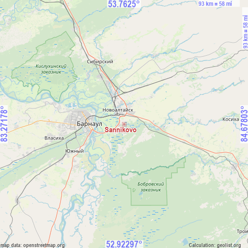
Sannikovo GPS coordinates[2]
53° 20' 41.28" North, 83° 58' 29.64" East
| Map corner | latitude | longitude |
|---|---|---|
| Upper-left | 53.7625°, | 83.27178° |
| Center: | 53.3448°, | 83.9749° |
| Lower-right: | 52.92297°, | 84.67803° |
| Map W x H: | 93.3×93.3 km | = 58×58mi |
| max Lat: | 73.50819° ⇑60% North |
| Sannikovo: | 53.3448° |
| min Lat: | ⇓40% South 41.28413° |
| min Long | Sannikovo | max Long |
| -179.12198° | 83.9749° | 179.35046° |
| W 81.5%⇐ | ⇒18.5% E |
Elevation
Elevation of Sannikovo is 142 m = 466 ft, and this is 60.6 m = 199 ft below average elevation for this country.
| Max E: |
2518 m = 8261 ft | 51.1% |
| Avg. | 202.6 m = 665 ft | |
| Sannikovo | 142 m = 466 ft | |
Min E: |
-28 m = -92 ft | 48.9% |
See also: Russia elevation on elevation.city.
Geographical zone
Sannikovo is located in North temperate zone (between Tropic of Cancer and the Arctic Circle). Distance of this North polar circle is 1469.8 km =913.3 mi to North.| Distance of | km | miles | from Sannikovo |
|---|---|---|---|
| North Pole | 4075.7 | 2532.5 | to North |
| Arctic Circle | 1469.8 | 913.3 | to North |
| Tropic Cancer | 3325.5 | 2066.4 | to South |
| Equator | 5931.4 | 3685.6 | to South |


Nearby cities:
15 places around Sannikovo: (largest is in red/bold)
• Barnaul
14.1 km =8.8 mi,  277°
277°
• Bayunovskiye Klyuchi
13.9 km =8.6 mi,  97°
97°
• Beloyarsk
12.2 km =7.6 mi,  337°
337°
• Bobrovka
19.1 km =11.9 mi,  200°
200°
• Borovikha
20.2 km =12.6 mi,  333°
333°
• Firsovo
3.3 km =2.1 mi, 204°
• Lebyazh’ye
24.2 km =15 mi,  242°
242°
• Lesnoy
11.4 km =7.1 mi,  181°
181°
• Logovskoye
22.4 km =13.9 mi,  42°
42°
• Novoaltaysk
5.8 km =3.6 mi, 333°
• Novosilikatnyy
23.6 km =14.7 mi,  260°
260°
• Vlasikha
27.1 km =16.8 mi, 258°
• Yuzhnyy
21.2 km =13.2 mi, 241°
• Zaton
12.5 km =7.8 mi, 242°
• Zudilovo
17.3 km =10.7 mi, 341°
Sources, notices
• [Note1] Compared only with cities in Russia existing in our database
• [Src1] Map data: © OpenStreetMap contributors (CC-BY-SA)
• [Src2] Other city data from geonames.org with taken over terms of usage.
• [Src3] Geographical zone / Annual Mean Temperature by Robert A. Rohde @ Wikipedia
