Velikodvorskiy geodata
Velikodvorskiy (Vladimir) is a populated place; located in Russia in Europe/Moscow (GMT+3) time zone. With population of 2,218 people, there are 4063 cities with bigger population in this country. Compared to other cities in Russia, 55.7% of cities are located further ↓South; 64.3% of cities are located further →East and 61% of cities have higher elevation than Velikodvorskiy. Note1


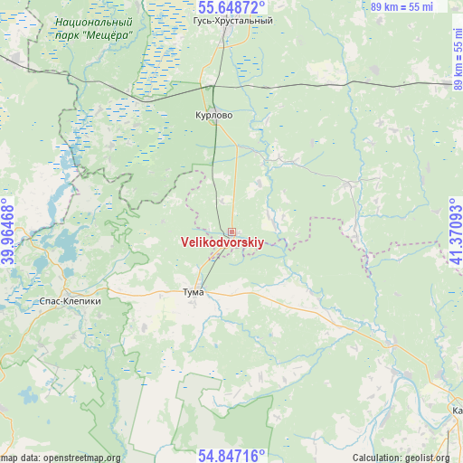
Velikodvorskiy GPS coordinates[2]
55° 14' 59.856" North, 40° 40' 4.08" East
| Map corner | latitude | longitude |
|---|---|---|
| Upper-left | 55.64872°, | 39.96468° |
| Center: | 55.24996°, | 40.6678° |
| Lower-right: | 54.84716°, | 41.37093° |
| Map W x H: | 89.1×89.1 km | = 55.4×55.4mi |
| max Lat: | 73.50819° ⇑44.3% North |
| Velikodvorskiy: | 55.24996° |
| min Lat: | ⇓55.7% South 41.28413° |
| min Long | Velikodvorskiy | max Long |
| -179.12198° | 40.6678° | 179.35046° |
| W 35.7%⇐ | ⇒64.3% E |
Elevation
Elevation of Velikodvorskiy is 122 m = 400 ft, and this is 80.6 m = 264 ft below average elevation for this country.
| Max E: |
2518 m = 8261 ft | 61% |
| Avg. | 202.6 m = 665 ft | |
| Velikodvorskiy | 122 m = 400 ft | |
Min E: |
-28 m = -92 ft | 39% |
See also: Russia elevation on elevation.city.
Geographical zone
Velikodvorskiy is located in North temperate zone (between Tropic of Cancer and the Arctic Circle). Distance of this North polar circle is 1258 km =781.7 mi to North.| Distance of | km | miles | from Velikodvorskiy |
|---|---|---|---|
| North Pole | 3863.8 | 2400.9 | to North |
| Arctic Circle | 1258 | 781.7 | to North |
| Tropic Cancer | 3537.3 | 2198 | to South |
| Equator | 6143.2 | 3817.2 | to South |


Nearby cities:
15 places around Velikodvorskiy: (largest is in red/bold)
• Anopino
49.8 km =30.9 mi,  359°
359°
• Cherusti
53.2 km =33.1 mi,  308°
308°
• Dobryatino
50 km =31.1 mi,  55°
55°
• Erleks
43 km =26.7 mi,  335°
335°
• Gusevskiy
46.3 km =28.8 mi,  351°
351°
• Gus’-Khrustal’nyy
40.2 km =25 mi, 358°
• Gus’-Zheleznyy
38.1 km =23.7 mi,  124°
124°
• Kurlovo
23.3 km =14.5 mi,  330°
330°
• Lashma
46.5 km =28.9 mi,  139°
139°
• Mezinovskiy
34.3 km =21.3 mi, 325°
• Savinskaya
44.8 km =27.8 mi,  287°
287°
• Spas-Klepiki
33.7 km =20.9 mi,  247°
247°
• Syntul
48.5 km =30.1 mi, 124°
• Tuma
13.5 km =8.4 mi,  212°
212°
• Zolotkovo
41.5 km =25.8 mi,  41°
41°
Sources, notices
• [Note1] Compared only with cities in Russia existing in our database
• [Src1] Map data: © OpenStreetMap contributors (CC-BY-SA)
• [Src2] Other city data from geonames.org with taken over terms of usage.
• [Src3] Geographical zone / Annual Mean Temperature by Robert A. Rohde @ Wikipedia
