Mezinovskiy geodata
Mezinovskiy (Vladimir) is a populated place; located in Russia in Europe/Moscow (GMT+3) time zone. With population of 2,116 people, there are 4105 cities with bigger population in this country. Compared to other cities in Russia, 58.2% of cities are located further ↓South; 65.8% of cities are located further →East and 58.6% of cities have higher elevation than Mezinovskiy. Note1


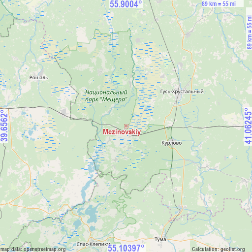
Mezinovskiy GPS coordinates[2]
55° 30' 15.12" North, 40° 21' 33.552" East
| Map corner | latitude | longitude |
|---|---|---|
| Upper-left | 55.9004°, | 39.6562° |
| Center: | 55.5042°, | 40.35932° |
| Lower-right: | 55.10397°, | 41.06245° |
| Map W x H: | 88.6×88.6 km | = 55.1×55.1mi |
| max Lat: | 73.50819° ⇑41.8% North |
| Mezinovskiy: | 55.5042° |
| min Lat: | ⇓58.2% South 41.28413° |
| min Long | Mezinovskiy | max Long |
| -179.12198° | 40.35932° | 179.35046° |
| W 34.2%⇐ | ⇒65.8% E |
Elevation
Elevation of Mezinovskiy is 127 m = 417 ft, and this is 75.6 m = 248 ft below average elevation for this country.
| Max E: |
2518 m = 8261 ft | 58.6% |
| Avg. | 202.6 m = 665 ft | |
| Mezinovskiy | 127 m = 417 ft | |
Min E: |
-28 m = -92 ft | 41.4% |
See also: Russia elevation on elevation.city.
Geographical zone
Mezinovskiy is located in North temperate zone (between Tropic of Cancer and the Arctic Circle). Distance of this North polar circle is 1229.7 km =764.1 mi to North.| Distance of | km | miles | from Mezinovskiy |
|---|---|---|---|
| North Pole | 3835.6 | 2383.3 | to North |
| Arctic Circle | 1229.7 | 764.1 | to North |
| Tropic Cancer | 3565.6 | 2215.6 | to South |
| Equator | 6171.5 | 3834.8 | to South |


Nearby cities:
15 places around Mezinovskiy: (largest is in red/bold)
• Anopino
29 km =18 mi,  41°
41°
• Baksheyevo
37.9 km =23.5 mi,  306°
306°
• Cherusti
22.5 km =14 mi,  283°
283°
• Dmitrovskiy Pogost
39.4 km =24.5 mi,  237°
237°
• Erleks
11 km =6.8 mi,  8°
8°
• Gusevskiy
21.7 km =13.5 mi, 36°
• Gus’-Khrustal’nyy
21.9 km =13.6 mi,  57°
57°
• Ivanishchi
30.3 km =18.8 mi, 8°
• Kurlovo
11.3 km =7 mi,  135°
135°
• Roshal’
35.5 km =22.1 mi,  300°
300°
• Savinskaya
27.5 km =17.1 mi, 237°
• Tugolesskiy Bor
34.1 km =21.2 mi, 278°
• Tuma
41.5 km =25.8 mi,  162°
162°
• Urshel’skiy
21.3 km =13.2 mi,  335°
335°
• Velikodvorskiy
34.3 km =21.3 mi,  145°
145°
Sources, notices
• [Note1] Compared only with cities in Russia existing in our database
• [Src1] Map data: © OpenStreetMap contributors (CC-BY-SA)
• [Src2] Other city data from geonames.org with taken over terms of usage.
• [Src3] Geographical zone / Annual Mean Temperature by Robert A. Rohde @ Wikipedia
