Zmiyëvka geodata
Zmiyëvka (Orel Oblast) is a populated place; located in Russia in Europe/Moscow (GMT+3) time zone. With population of 6,288 people, there are 2185 cities with bigger population in this country. Compared to other cities in Russia, 65.1% of cities are located further ↑North; 86.6% of cities are located further →East and 76.1% of cities have lower elevation than Zmiyëvka. Note1


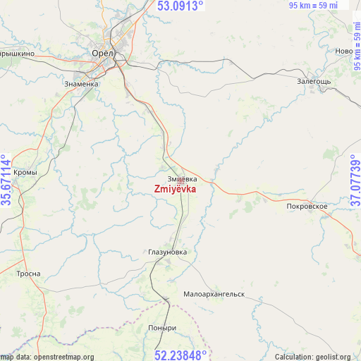
Zmiyëvka GPS coordinates[2]
52° 40' 1.092" North, 36° 22' 27.336" East
| Map corner | latitude | longitude |
|---|---|---|
| Upper-left | 53.0913°, | 35.67114° |
| Center: | 52.66697°, | 36.37426° |
| Lower-right: | 52.23848°, | 37.07739° |
| Map W x H: | 94.8×94.8 km | = 58.9×58.9mi |
| max Lat: | 73.50819° ⇑65.1% North |
| Zmiyëvka: | 52.66697° |
| min Lat: | ⇓34.9% South 41.28413° |
| min Long | Zmiyëvka | max Long |
| -179.12198° | 36.37426° | 179.35046° |
| W 13.4%⇐ | ⇒86.6% E |
Elevation
Elevation of Zmiyëvka is 221 m = 725 ft, and this is 18.4 m = 60 ft above average elevation for this country.
| Max E: |
2518 m = 8261 ft | 23.9% |
| Zmiyëvka | 221 m 725 ft | |
| Avg. | 202.6 m = 665 ft | |
Min E: |
-28 m = -92 ft | 76.1% |
See also: Russia elevation on elevation.city.
Geographical zone
Zmiyëvka is located in North temperate zone (between Tropic of Cancer and the Arctic Circle). Distance of this North polar circle is 1545.2 km =960.1 mi to North.| Distance of | km | miles | from Zmiyëvka |
|---|---|---|---|
| North Pole | 4151 | 2579.3 | to North |
| Arctic Circle | 1545.2 | 960.1 | to North |
| Tropic Cancer | 3250.1 | 2019.5 | to South |
| Equator | 5856 | 3638.7 | to South |


Nearby cities:
15 places around Zmiyëvka: (largest is in red/bold)
• Glazunovka
18.9 km =11.7 mi,  191°
191°
• Kolpny
66.3 km =41.2 mi,  137°
137°
• Kromy
41 km =25.5 mi,  273°
273°
• Maloarkhangel’sk
30.9 km =19.2 mi,  163°
163°
• Naryshkino
54.9 km =34.1 mi,  307°
307°
• Novosil’
56.3 km =35 mi,  52°
52°
• Orël
38.6 km =24 mi,  329°
329°
• Pokrovskoye
34.1 km =21.2 mi,  100°
100°
• Ponyri Vtoryye
44.2 km =27.5 mi, 193°
• Soskovo
67.4 km =41.9 mi,  277°
277°
• Trosna
47.2 km =29.3 mi,  238°
238°
• Verkhov’ye
60.6 km =37.7 mi,  74°
74°
• Zalegoshch’
43.3 km =26.9 mi, 53°
• Znamenka
37.1 km =23.1 mi, 313°
• Zolotukhino
64.8 km =40.3 mi,  179°
179°
Sources, notices
• [Note1] Compared only with cities in Russia existing in our database
• [Src1] Map data: © OpenStreetMap contributors (CC-BY-SA)
• [Src2] Other city data from geonames.org with taken over terms of usage.
• [Src3] Geographical zone / Annual Mean Temperature by Robert A. Rohde @ Wikipedia
