Pokrovskoye geodata
Pokrovskoye (Orel Oblast) is a populated place; located in Russia in Europe/Moscow (GMT+3) time zone. With population of 4,566 people, there are 2841 cities with bigger population in this country. Compared to other cities in Russia, 65.4% of cities are located further ↑North; 85.2% of cities are located further →East and 69.5% of cities have lower elevation than Pokrovskoye. Note1


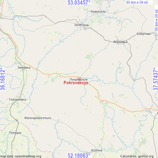
Pokrovskoye GPS coordinates[2]
52° 36' 34.848" North, 36° 52' 16.464" East
| Map corner | latitude | longitude |
|---|---|---|
| Upper-left | 53.03457°, | 36.16812° |
| Center: | 52.60968°, | 36.87124° |
| Lower-right: | 52.18063°, | 37.57437° |
| Map W x H: | 94.9×94.9 km | = 59×59mi |
| max Lat: | 73.50819° ⇑65.4% North |
| Pokrovskoye: | 52.60968° |
| min Lat: | ⇓34.6% South 41.28413° |
| min Long | Pokrovskoye | max Long |
| -179.12198° | 36.87124° | 179.35046° |
| W 14.8%⇐ | ⇒85.2% E |
Elevation
Elevation of Pokrovskoye is 196 m = 643 ft, and this is 6.6 m = 22 ft below average elevation for this country.
| Max E: |
2518 m = 8261 ft | 30.5% |
| Avg. | 202.6 m = 665 ft | |
| Pokrovskoye | 196 m = 643 ft | |
Min E: |
-28 m = -92 ft | 69.5% |
See also: Russia elevation on elevation.city.
Geographical zone
Pokrovskoye is located in North temperate zone (between Tropic of Cancer and the Arctic Circle). Distance of this North polar circle is 1551.5 km =964.1 mi to North.| Distance of | km | miles | from Pokrovskoye |
|---|---|---|---|
| North Pole | 4157.4 | 2583.3 | to North |
| Arctic Circle | 1551.5 | 964.1 | to North |
| Tropic Cancer | 3243.7 | 2015.5 | to South |
| Equator | 5849.6 | 3634.8 | to South |


Nearby cities:
15 places around Pokrovskoye: (largest is in red/bold)
• Glazunovka
39.2 km =24.4 mi,  251°
251°
• Khomutovo
46.9 km =29.1 mi,  54°
54°
• Kolpny
43.9 km =27.3 mi,  165°
165°
• Krasnaya Zarya
57.8 km =35.9 mi,  70°
70°
• Livny
53.8 km =33.4 mi,  112°
112°
• Maloarkhangel’sk
34.1 km =21.2 mi,  226°
226°
• Novosil’
42.1 km =26.2 mi,  15°
15°
• Orël
66.4 km =41.3 mi,  306°
306°
• Ponyri Vtoryye
57.1 km =35.5 mi, 230°
• Verkhov’ye
33.6 km =20.9 mi, 48°
• Vyshneye Dolgoye
70.8 km =44 mi,  149°
149°
• Zalegoshch’
32.2 km =20 mi,  2°
2°
• Zmiyëvka
34.1 km =21.2 mi,  280°
280°
• Znamenka
68.2 km =42.4 mi,  298°
298°
• Zolotukhino
67.4 km =41.9 mi,  209°
209°
Sources, notices
• [Note1] Compared only with cities in Russia existing in our database
• [Src1] Map data: © OpenStreetMap contributors (CC-BY-SA)
• [Src2] Other city data from geonames.org with taken over terms of usage.
• [Src3] Geographical zone / Annual Mean Temperature by Robert A. Rohde @ Wikipedia
