Kolpny geodata
Kolpny (Orel Oblast) is a populated place; located in Russia in Europe/Moscow (GMT+3) time zone. With population of 7,081 people, there are 1979 cities with bigger population in this country. Compared to other cities in Russia, 67.8% of cities are located further ↑North; 84.8% of cities are located further →East and 60.9% of cities have lower elevation than Kolpny. Note1


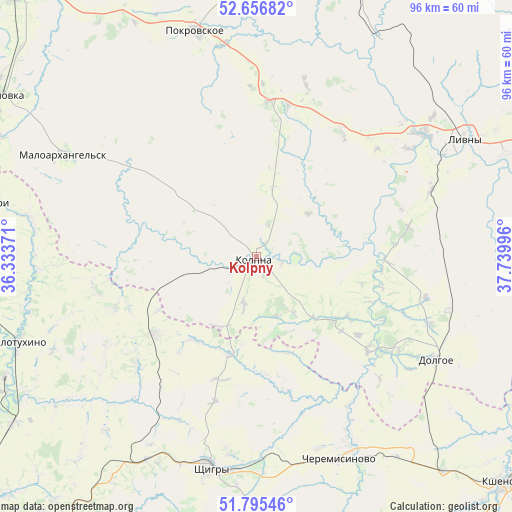
Kolpny GPS coordinates[2]
52° 13' 41.628" North, 37° 2' 12.588" East
| Map corner | latitude | longitude |
|---|---|---|
| Upper-left | 52.65682°, | 36.33371° |
| Center: | 52.22823°, | 37.03683° |
| Lower-right: | 51.79546°, | 37.73996° |
| Map W x H: | 95.8×95.8 km | = 59.5×59.5mi |
| max Lat: | 73.50819° ⇑67.8% North |
| Kolpny: | 52.22823° |
| min Lat: | ⇓32.2% South 41.28413° |
| min Long | Kolpny | max Long |
| -179.12198° | 37.03683° | 179.35046° |
| W 15.2%⇐ | ⇒84.8% E |
Elevation
Elevation of Kolpny is 171 m = 561 ft, and this is 31.6 m = 104 ft below average elevation for this country.
| Max E: |
2518 m = 8261 ft | 39.1% |
| Avg. | 202.6 m = 665 ft | |
| Kolpny | 171 m = 561 ft | |
Min E: |
-28 m = -92 ft | 60.9% |
See also: Russia elevation on elevation.city.
Geographical zone
Kolpny is located in North temperate zone (between Tropic of Cancer and the Arctic Circle). Distance of this North polar circle is 1593.9 km =990.4 mi to North.| Distance of | km | miles | from Kolpny |
|---|---|---|---|
| North Pole | 4199.8 | 2609.6 | to North |
| Arctic Circle | 1593.9 | 990.4 | to North |
| Tropic Cancer | 3201.3 | 1989.2 | to South |
| Equator | 5807.2 | 3608.4 | to South |


Nearby cities:
15 places around Kolpny: (largest is in red/bold)
• Cheremisinovo
41.2 km =25.6 mi,  157°
157°
• Glazunovka
57.3 km =35.6 mi,  301°
301°
• Khomutovo
74.7 km =46.4 mi,  21°
21°
• Kshenskiy
63.2 km =39.3 mi,  132°
132°
• Livny
44.5 km =27.7 mi,  60°
60°
• Maloarkhangel’sk
41 km =25.5 mi, 297°
• Pokrovskoye
43.9 km =27.3 mi,  345°
345°
• Ponyri Vtoryye
55.6 km =34.5 mi,  275°
275°
• Shchigry
40.2 km =25 mi,  193°
193°
• Tim
67.6 km =42 mi,  174°
174°
• Verkhov’ye
66.3 km =41.2 mi,  12°
12°
• Volovo
62.1 km =38.6 mi,  111°
111°
• Vyshneye Dolgoye
31.1 km =19.3 mi, 126°
• Zmiyëvka
66.3 km =41.2 mi,  317°
317°
• Zolotukhino
47.7 km =29.6 mi,  250°
250°
Sources, notices
• [Note1] Compared only with cities in Russia existing in our database
• [Src1] Map data: © OpenStreetMap contributors (CC-BY-SA)
• [Src2] Other city data from geonames.org with taken over terms of usage.
• [Src3] Geographical zone / Annual Mean Temperature by Robert A. Rohde @ Wikipedia
