Masalovka geodata
Masalovka (Rostov) is a populated place; located in Russia in Europe/Moscow (GMT+3) time zone. With population of 8,948 people, there are 1665 cities with bigger population in this country. Compared to other cities in Russia, 79.9% of cities are located further ↑North; 66.1% of cities are located further →East and 89.6% of cities have higher elevation than Masalovka. Note1


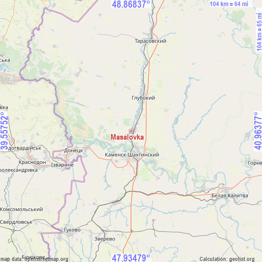
Masalovka GPS coordinates[2]
48° 24' 13.392" North, 40° 15' 38.304" East
| Map corner | latitude | longitude |
|---|---|---|
| Upper-left | 48.86837°, | 39.55752° |
| Center: | 48.40372°, | 40.26064° |
| Lower-right: | 47.93479°, | 40.96377° |
| Map W x H: | 103.8×103.8 km | = 64.5×64.5mi |
| max Lat: | 73.50819° ⇑79.9% North |
| Masalovka: | 48.40372° |
| min Lat: | ⇓20.1% South 41.28413° |
| min Long | Masalovka | max Long |
| -179.12198° | 40.26064° | 179.35046° |
| W 33.9%⇐ | ⇒66.1% E |
Elevation
Elevation of Masalovka is 30 m = 98 ft, and this is 172.6 m = 566 ft below average elevation for this country.
| Max E: |
2518 m = 8261 ft | 89.6% |
| Avg. | 202.6 m = 665 ft | |
| Masalovka | 30 m = 98 ft | |
Min E: |
-28 m = -92 ft | 10.4% |
See also: Russia elevation on elevation.city.
Geographical zone
Masalovka is located in North temperate zone (between Tropic of Cancer and the Arctic Circle). Distance of this North polar circle is 2019.2 km =1254.7 mi to North.| Distance of | km | miles | from Masalovka |
|---|---|---|---|
| North Pole | 4625.1 | 2873.9 | to North |
| Arctic Circle | 2019.2 | 1254.7 | to North |
| Tropic Cancer | 2776.1 | 1725 | to South |
| Equator | 5382 | 3344.2 | to South |


Nearby cities:
15 places around Masalovka: (largest is in red/bold)
• Almaznyy
43 km =26.7 mi,  201°
201°
• Belaya Kalitva
45.1 km =28 mi,  122°
122°
• Donetsk
23.4 km =14.5 mi,  252°
252°
• Glubokiy
14.7 km =9.1 mi,  20°
20°
• Gornyatskiy
50.5 km =31.4 mi,  103°
103°
• Gukovo
45 km =28 mi,  212°
212°
• Kamensk-Shakhtinskiy
9.6 km =6 mi,  180°
180°
• Koksovyy
36.4 km =22.6 mi,  129°
129°
• Krasnovka
47.7 km =29.6 mi,  344°
344°
• Likhovskoy
28.6 km =17.8 mi,  192°
192°
• Likhoy
31.1 km =19.3 mi, 187°
• Staraya Stanitsa
6.9 km =4.3 mi,  159°
159°
• Tarasovskiy
36.8 km =22.9 mi,  11°
11°
• Uglerodovskiy
32.2 km =20 mi, 206°
• Zverevo
43.8 km =27.2 mi, 193°
Sources, notices
• [Note1] Compared only with cities in Russia existing in our database
• [Src1] Map data: © OpenStreetMap contributors (CC-BY-SA)
• [Src2] Other city data from geonames.org with taken over terms of usage.
• [Src3] Geographical zone / Annual Mean Temperature by Robert A. Rohde @ Wikipedia
