Gornyatskiy geodata
Gornyatskiy (Rostov) is a populated place; located in Russia in Europe/Moscow (GMT+3) time zone. With population of 9,292 people, there are 1616 cities with bigger population in this country. Compared to other cities in Russia, 80.1% of cities are located further ↑North; 63.4% of cities are located further →East and 72.4% of cities have higher elevation than Gornyatskiy. Note1


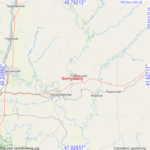
Gornyatskiy GPS coordinates[2]
48° 17' 47.364" North, 40° 55' 26.544" East
| Map corner | latitude | longitude |
|---|---|---|
| Upper-left | 48.76212°, | 40.22092° |
| Center: | 48.29649°, | 40.92404° |
| Lower-right: | 47.82657°, | 41.62717° |
| Map W x H: | 104×104 km | = 64.6×64.6mi |
| max Lat: | 73.50819° ⇑80.1% North |
| Gornyatskiy: | 48.29649° |
| min Lat: | ⇓19.9% South 41.28413° |
| min Long | Gornyatskiy | max Long |
| -179.12198° | 40.92404° | 179.35046° |
| W 36.6%⇐ | ⇒63.4% E |
Elevation
Elevation of Gornyatskiy is 96 m = 315 ft, and this is 106.6 m = 350 ft below average elevation for this country.
| Max E: |
2518 m = 8261 ft | 72.4% |
| Avg. | 202.6 m = 665 ft | |
| Gornyatskiy | 96 m = 315 ft | |
Min E: |
-28 m = -92 ft | 27.6% |
See also: Russia elevation on elevation.city.
Geographical zone
Gornyatskiy is located in North temperate zone (between Tropic of Cancer and the Arctic Circle). Distance of this North polar circle is 2031.1 km =1262.1 mi to North.| Distance of | km | miles | from Gornyatskiy |
|---|---|---|---|
| North Pole | 4637 | 2881.3 | to North |
| Arctic Circle | 2031.1 | 1262.1 | to North |
| Tropic Cancer | 2764.1 | 1717.5 | to South |
| Equator | 5370.1 | 3336.8 | to South |


Nearby cities:
15 places around Gornyatskiy: (largest is in red/bold)
• Belaya Kalitva
16.6 km =10.3 mi,  222°
222°
• Bystrogorskiy
18.8 km =11.7 mi,  121°
121°
• Glubokiy
50.7 km =31.5 mi,  300°
300°
• Kamensk-Shakhtinskiy
49.2 km =30.6 mi,  272°
272°
• Koksovyy
23.5 km =14.6 mi,  242°
242°
• Likhovskoy
57.5 km =35.7 mi,  253°
253°
• Likhoy
56.5 km =35.1 mi, 250°
• Masalovka
50.5 km =31.4 mi,  283°
283°
• Sholokhovskiy
9.2 km =5.7 mi,  101°
101°
• Sinegorskiy
32 km =19.9 mi,  190°
190°
• Staraya Stanitsa
46.9 km =29.1 mi, 276°
• Tarasovskiy
63.3 km =39.3 mi,  319°
319°
• Tatsinskiy
28.3 km =17.6 mi,  113°
113°
• Uglegorskiy
25.1 km =15.6 mi, 103°
• Zhirnov
20.5 km =12.7 mi,  133°
133°
Sources, notices
• [Note1] Compared only with cities in Russia existing in our database
• [Src1] Map data: © OpenStreetMap contributors (CC-BY-SA)
• [Src2] Other city data from geonames.org with taken over terms of usage.
• [Src3] Geographical zone / Annual Mean Temperature by Robert A. Rohde @ Wikipedia
