Glubokiy geodata
Glubokiy (Rostov) is a populated place; located in Russia in Europe/Moscow (GMT+3) time zone. With population of 11,225 people, there are 1345 cities with bigger population in this country. Compared to other cities in Russia, 79.8% of cities are located further ↑North; 65.9% of cities are located further →East and 80.3% of cities have higher elevation than Glubokiy. Note1


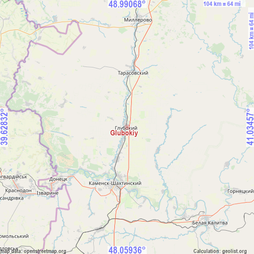
Glubokiy GPS coordinates[2]
48° 31' 37.776" North, 40° 19' 53.184" East
| Map corner | latitude | longitude |
|---|---|---|
| Upper-left | 48.99068°, | 39.62832° |
| Center: | 48.52716°, | 40.33144° |
| Lower-right: | 48.05936°, | 41.03457° |
| Map W x H: | 103.6×103.6 km | = 64.4×64.4mi |
| max Lat: | 73.50819° ⇑79.8% North |
| Glubokiy: | 48.52716° |
| min Lat: | ⇓20.2% South 41.28413° |
| min Long | Glubokiy | max Long |
| -179.12198° | 40.33144° | 179.35046° |
| W 34.1%⇐ | ⇒65.9% E |
Elevation
Elevation of Glubokiy is 70 m = 230 ft, and this is 132.6 m = 435 ft below average elevation for this country.
| Max E: |
2518 m = 8261 ft | 80.3% |
| Avg. | 202.6 m = 665 ft | |
| Glubokiy | 70 m = 230 ft | |
Min E: |
-28 m = -92 ft | 19.7% |
See also: Russia elevation on elevation.city.
Geographical zone
Glubokiy is located in North temperate zone (between Tropic of Cancer and the Arctic Circle). Distance of this North polar circle is 2005.5 km =1246.2 mi to North.| Distance of | km | miles | from Glubokiy |
|---|---|---|---|
| North Pole | 4611.3 | 2865.3 | to North |
| Arctic Circle | 2005.5 | 1246.2 | to North |
| Tropic Cancer | 2789.8 | 1733.5 | to South |
| Equator | 5395.7 | 3352.7 | to South |


Nearby cities:
15 places around Glubokiy: (largest is in red/bold)
• Almaznyy
57.7 km =35.9 mi,  201°
201°
• Belaya Kalitva
50.1 km =31.1 mi,  139°
139°
• Donetsk
34.5 km =21.4 mi,  232°
232°
• Gornyatskiy
50.7 km =31.5 mi,  120°
120°
• Kamensk-Shakhtinskiy
23.9 km =14.9 mi,  192°
192°
• Koksovyy
43.3 km =26.9 mi,  147°
147°
• Krasnovka
36.8 km =22.9 mi,  331°
331°
• Likhovskoy
43.2 km =26.8 mi, 195°
• Likhoy
45.5 km =28.3 mi, 191°
• Masalovka
14.7 km =9.1 mi, 200°
• Millerovo
44.2 km =27.5 mi,  6°
6°
• Staraya Stanitsa
20.4 km =12.7 mi, 187°
• Tarasovskiy
22.4 km =13.9 mi, 5°
• Uglerodovskiy
46.8 km =29.1 mi,  205°
205°
• Zverevo
58.4 km =36.3 mi, 195°
Sources, notices
• [Note1] Compared only with cities in Russia existing in our database
• [Src1] Map data: © OpenStreetMap contributors (CC-BY-SA)
• [Src2] Other city data from geonames.org with taken over terms of usage.
• [Src3] Geographical zone / Annual Mean Temperature by Robert A. Rohde @ Wikipedia
