Gukovo geodata
Gukovo (Rostov) is a populated place; located in Russia in Europe/Moscow (GMT+3) time zone. With population of 66,079 people, there are 311 cities with bigger population in this country. Compared to other cities in Russia, 80.5% of cities are located further ↑North; 67.8% of cities are located further →East and 80.5% of cities have lower elevation than Gukovo. Note1


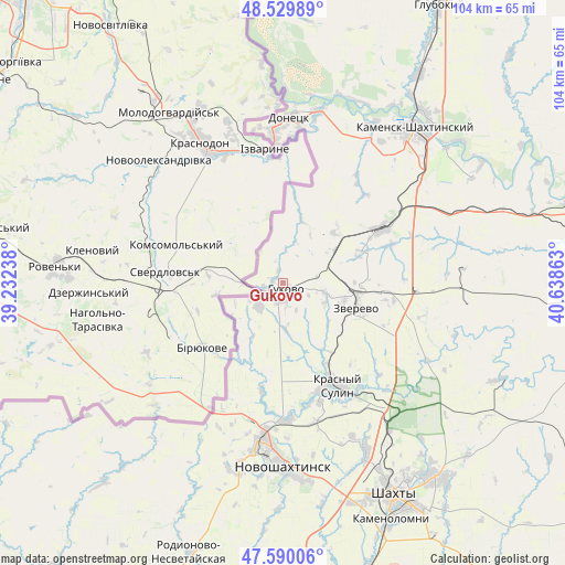
Gukovo GPS coordinates[2]
48° 3' 43.632" North, 39° 56' 7.8" East
| Map corner | latitude | longitude |
|---|---|---|
| Upper-left | 48.52989°, | 39.23238° |
| Center: | 48.06212°, | 39.9355° |
| Lower-right: | 47.59006°, | 40.63863° |
| Map W x H: | 104.5×104.5 km | = 64.9×64.9mi |
| max Lat: | 73.50819° ⇑80.5% North |
| Gukovo: | 48.06212° |
| min Lat: | ⇓19.5% South 41.28413° |
| min Long | Gukovo | max Long |
| -179.12198° | 39.9355° | 179.35046° |
| W 32.2%⇐ | ⇒67.8% E |
Elevation
Elevation of Gukovo is 252 m = 827 ft, and this is 49.4 m = 162 ft above average elevation for this country.
| Max E: |
2518 m = 8261 ft | 19.5% |
| Gukovo | 252 m 827 ft | |
| Avg. | 202.6 m = 665 ft | |
Min E: |
-28 m = -92 ft | 80.5% |
See also: Gukovo elevation on elevation.city.
Geographical zone
Gukovo is located in North temperate zone (between Tropic of Cancer and the Arctic Circle). Distance of this North polar circle is 2057.2 km =1278.3 mi to North.| Distance of | km | miles | from Gukovo |
|---|---|---|---|
| North Pole | 4663.1 | 2897.5 | to North |
| Arctic Circle | 2057.2 | 1278.3 | to North |
| Tropic Cancer | 2738.1 | 1701.4 | to South |
| Equator | 5344 | 3320.6 | to South |


Nearby cities:
15 places around Gukovo: (largest is in red/bold)
• Almaznyy
8.4 km =5.2 mi,  103°
103°
• Ayutinskiy
34.9 km =21.7 mi,  153°
153°
• Donetsk
30.9 km =19.2 mi,  3°
3°
• Gornyy
33.9 km =21.1 mi,  143°
143°
• Kamensk-Shakhtinskiy
37.2 km =23.1 mi,  40°
40°
• Krasnyy Sulin
21.4 km =13.3 mi, 152°
• Likhovskoy
20.7 km =12.9 mi,  61°
61°
• Likhoy
21.3 km =13.2 mi,  70°
70°
• Novoshakhtinsk
33.6 km =20.9 mi,  180°
180°
• Sambek
36.3 km =22.6 mi,  192°
192°
• Sokolovo-Kundryuchenskiy
25.2 km =15.7 mi, 178°
• Staraya Stanitsa
41.2 km =25.6 mi, 40°
• Talovyy
31.1 km =19.3 mi,  155°
155°
• Uglerodovskiy
13.3 km =8.3 mi,  45°
45°
• Zverevo
14.7 km =9.1 mi,  108°
108°
Sources, notices
• [Note1] Compared only with cities in Russia existing in our database
• [Src1] Map data: © OpenStreetMap contributors (CC-BY-SA)
• [Src2] Other city data from geonames.org with taken over terms of usage.
• [Src3] Geographical zone / Annual Mean Temperature by Robert A. Rohde @ Wikipedia
