Yasenevo geodata
Yasenevo (Moscow) is a section of populated place; located in Russia in Europe/Moscow (GMT+3) time zone. With population of 180,000 people, there are 108 cities with bigger population in this country. Compared to other cities in Russia, 59.8% of cities are located further ↓South; 81.6% of cities are located further →East and 77.3% of cities have lower elevation than Yasenevo. Note1


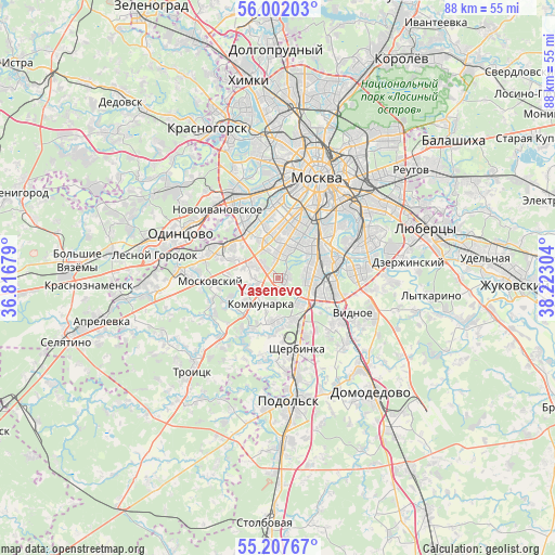
Yasenevo GPS coordinates[2]
55° 36' 24.696" North, 37° 31' 11.676" East
| Map corner | latitude | longitude |
|---|---|---|
| Upper-left | 56.00203°, | 36.81679° |
| Center: | 55.60686°, | 37.51991° |
| Lower-right: | 55.20767°, | 38.22304° |
| Map W x H: | 88.3×88.3 km | = 54.9×54.9mi |
| max Lat: | 73.50819° ⇑40.2% North |
| Yasenevo: | 55.60686° |
| min Lat: | ⇓59.8% South 41.28413° |
| min Long | Yasenevo | max Long |
| -179.12198° | 37.51991° | 179.35046° |
| W 18.4%⇐ | ⇒81.6% E |
Elevation
Elevation of Yasenevo is 228 m = 748 ft, and this is 25.4 m = 83 ft above average elevation for this country.
| Max E: |
2518 m = 8261 ft | 22.7% |
| Yasenevo | 228 m 748 ft | |
| Avg. | 202.6 m = 665 ft | |
Min E: |
-28 m = -92 ft | 77.3% |
See also: Yasenevo elevation on elevation.city.
Geographical zone
Yasenevo is located in North temperate zone (between Tropic of Cancer and the Arctic Circle). Distance of this North polar circle is 1218.3 km =757 mi to North.| Distance of | km | miles | from Yasenevo |
|---|---|---|---|
| North Pole | 3824.2 | 2376.2 | to North |
| Arctic Circle | 1218.3 | 757 | to North |
| Tropic Cancer | 3577 | 2222.6 | to South |
| Equator | 6182.9 | 3841.9 | to South |


Nearby cities:
15 places around Yasenevo: (largest is in red/bold)
• Annino
5.7 km =3.5 mi,  117°
117°
• Biryulëvo Zapadnoye
8 km =5 mi,  105°
105°
• Chertanovo Yuzhnoye
5.1 km =3.2 mi, 110°
• Cherëmushki
6.9 km =4.3 mi,  22°
22°
• Kommunarka
4.6 km =2.9 mi,  204°
204°
• Kotlovka
7.9 km =4.9 mi,  42°
42°
• Mamyri
4.6 km =2.9 mi,  252°
252°
• Mosrentgen
3.8 km =2.4 mi,  292°
292°
• Nagornyy
7.7 km =4.8 mi,  51°
51°
• Nikulino
7.7 km =4.8 mi,  334°
334°
• Troparëvo
5.9 km =3.7 mi,  338°
338°
• Tsaritsyno
8.4 km =5.2 mi,  75°
75°
• Tyoply Stan
2.3 km =1.4 mi,  312°
312°
• Vostryakovo
8 km =5 mi, 326°
• Zyuzino
6.3 km =3.9 mi,  29°
29°
Sources, notices
• [Note1] Compared only with cities in Russia existing in our database
• [Src1] Map data: © OpenStreetMap contributors (CC-BY-SA)
• [Src2] Other city data from geonames.org with taken over terms of usage.
• [Src3] Geographical zone / Annual Mean Temperature by Robert A. Rohde @ Wikipedia
