Zyuzino geodata
Zyuzino (Moscow) is a section of populated place; located in Russia in Europe/Moscow (GMT+3) time zone. With population of 121,000 people, there are 167 cities with bigger population in this country. Compared to other cities in Russia, 60.8% of cities are located further ↓South; 80.9% of cities are located further →East and 71.7% of cities have lower elevation than Zyuzino. Note1


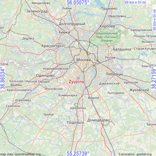
Zyuzino GPS coordinates[2]
55° 39' 21.888" North, 37° 34' 6.456" East
| Map corner | latitude | longitude |
|---|---|---|
| Upper-left | 56.05075°, | 36.86534° |
| Center: | 55.65608°, | 37.56846° |
| Lower-right: | 55.25739°, | 38.27159° |
| Map W x H: | 88.2×88.2 km | = 54.8×54.8mi |
| max Lat: | 73.50819° ⇑39.2% North |
| Zyuzino: | 55.65608° |
| min Lat: | ⇓60.8% South 41.28413° |
| min Long | Zyuzino | max Long |
| -179.12198° | 37.56846° | 179.35046° |
| W 19.1%⇐ | ⇒80.9% E |
Elevation
Elevation of Zyuzino is 203 m = 666 ft, and this is 0.40000000000001 m = 1 ft above average elevation for this country.
| Max E: |
2518 m = 8261 ft | 28.3% |
| Zyuzino | 203 m 666 ft | |
| Avg. | 202.6 m = 665 ft | |
Min E: |
-28 m = -92 ft | 71.7% |
See also: Zyuzino elevation on elevation.city.
Geographical zone
Zyuzino is located in North temperate zone (between Tropic of Cancer and the Arctic Circle). Distance of this North polar circle is 1212.8 km =753.6 mi to North.| Distance of | km | miles | from Zyuzino |
|---|---|---|---|
| North Pole | 3818.7 | 2372.8 | to North |
| Arctic Circle | 1212.8 | 753.6 | to North |
| Tropic Cancer | 3582.5 | 2226.1 | to South |
| Equator | 6188.4 | 3845.3 | to South |


Nearby cities:
15 places around Zyuzino: (largest is in red/bold)
• Cherëmushki
1.1 km =0.7 mi,  335°
335°
• Kotlovka
2.3 km =1.4 mi,  80°
80°
• Leninskiye Gory
4.9 km =3 mi,  358°
358°
• Luzhniki
6.7 km =4.2 mi,  352°
352°
• Nagornyy
3.1 km =1.9 mi,  102°
102°
• Nikol’skoye
6.1 km =3.8 mi,  299°
299°
• Nikulino
6.6 km =4.1 mi,  283°
283°
• Novyye Cherëmushki
5 km =3.1 mi,  10°
10°
• Ramenki
6.5 km =4 mi,  318°
318°
• Semënovskoye
3.2 km =2 mi, 339°
• Troparëvo
5.2 km =3.2 mi,  270°
270°
• Tsaritsyno
6.2 km =3.9 mi,  123°
123°
• Tyoply Stan
6.2 km =3.9 mi,  229°
229°
• Vorob’yovo
7.1 km =4.4 mi, 341°
• Yasenevo
6.3 km =3.9 mi,  209°
209°
Sources, notices
• [Note1] Compared only with cities in Russia existing in our database
• [Src1] Map data: © OpenStreetMap contributors (CC-BY-SA)
• [Src2] Other city data from geonames.org with taken over terms of usage.
• [Src3] Geographical zone / Annual Mean Temperature by Robert A. Rohde @ Wikipedia
