Pashkovskiy geodata
Pashkovskiy (Krasnodarskiy) is a section of populated place; located in Russia in Europe/Moscow (GMT+3) time zone. With population of 43,634 people, there are 481 cities with bigger population in this country. Compared to other cities in Russia, 87.2% of cities are located further ↑North; 71.6% of cities are located further →East and 89.8% of cities have higher elevation than Pashkovskiy. Note1


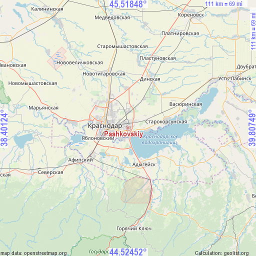
Pashkovskiy GPS coordinates[2]
45° 1' 25.176" North, 39° 6' 15.696" East
| Map corner | latitude | longitude |
|---|---|---|
| Upper-left | 45.51848°, | 38.40124° |
| Center: | 45.02366°, | 39.10436° |
| Lower-right: | 44.52452°, | 39.80749° |
| Map W x H: | 110.5×110.5 km | = 68.7×68.7mi |
| max Lat: | 73.50819° ⇑87.2% North |
| Pashkovskiy: | 45.02366° |
| min Lat: | ⇓12.8% South 41.28413° |
| min Long | Pashkovskiy | max Long |
| -179.12198° | 39.10436° | 179.35046° |
| W 28.4%⇐ | ⇒71.6% E |
Elevation
Elevation of Pashkovskiy is 29 m = 95 ft, and this is 173.6 m = 570 ft below average elevation for this country.
| Max E: |
2518 m = 8261 ft | 89.8% |
| Avg. | 202.6 m = 665 ft | |
| Pashkovskiy | 29 m = 95 ft | |
Min E: |
-28 m = -92 ft | 10.2% |
See also: Pashkovskiy elevation on elevation.city.
Geographical zone
Pashkovskiy is located in North temperate zone (between Tropic of Cancer and the Arctic Circle). Distance of this North polar circle is 2395 km =1488.2 mi to North.| Distance of | km | miles | from Pashkovskiy |
|---|---|---|---|
| North Pole | 5000.9 | 3107.4 | to North |
| Arctic Circle | 2395 | 1488.2 | to North |
| Tropic Cancer | 2400.2 | 1491.4 | to South |
| Equator | 5006.2 | 3110.7 | to South |


Nearby cities:
15 places around Pashkovskiy: (largest is in red/bold)
• Adygeysk
16.9 km =10.5 mi,  156°
156°
• Afipskiy
24.8 km =15.4 mi,  236°
236°
• Agronom
14.8 km =9.2 mi,  28°
28°
• Dinskaya
23.3 km =14.5 mi,  24°
24°
• Enem
19 km =11.8 mi, 235°
• Krasnodar
10.4 km =6.5 mi,  283°
283°
• Novodmitriyevskaya
27.7 km =17.2 mi,  219°
219°
• Novotitarovskaya
25.7 km =16 mi,  337°
337°
• Ponezhukay
26.8 km =16.7 mi,  124°
124°
• Starokorsunskaya
17.1 km =10.6 mi,  77°
77°
• Takhtamukay
14.2 km =8.8 mi, 216°
• Tlyustenkhabl’
4.7 km =2.9 mi,  186°
186°
• Vasyurinskaya
27.2 km =16.9 mi,  67°
67°
• Yablonovskiy
13.2 km =8.2 mi,  253°
253°
• Yelizavetinskaya
24.4 km =15.2 mi, 275°
Sources, notices
• [Note1] Compared only with cities in Russia existing in our database
• [Src1] Map data: © OpenStreetMap contributors (CC-BY-SA)
• [Src2] Other city data from geonames.org with taken over terms of usage.
• [Src3] Geographical zone / Annual Mean Temperature by Robert A. Rohde @ Wikipedia
