Starokorsunskaya geodata
Starokorsunskaya (Krasnodarskiy) is a populated place; located in Russia in Europe/Moscow (GMT+3) time zone. With population of 10,915 people, there are 1384 cities with bigger population in this country. Compared to other cities in Russia, 87% of cities are located further ↑North; 70.9% of cities are located further →East and 87.5% of cities have higher elevation than Starokorsunskaya. Note1


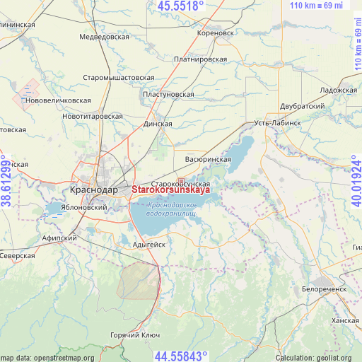
Starokorsunskaya GPS coordinates[2]
45° 3' 26.172" North, 39° 18' 57.996" East
| Map corner | latitude | longitude |
|---|---|---|
| Upper-left | 45.5518°, | 38.61299° |
| Center: | 45.05727°, | 39.31611° |
| Lower-right: | 44.55843°, | 40.01924° |
| Map W x H: | 110.5×110.5 km | = 68.7×68.7mi |
| max Lat: | 73.50819° ⇑87% North |
| Starokorsunskaya: | 45.05727° |
| min Lat: | ⇓13% South 41.28413° |
| min Long | Starokorsunskay | max Long |
| -179.12198° | 39.31611° | 179.35046° |
| W 29.1%⇐ | ⇒70.9% E |
Elevation
Elevation of Starokorsunskaya is 38 m = 125 ft, and this is 164.6 m = 540 ft below average elevation for this country.
| Max E: |
2518 m = 8261 ft | 87.5% |
| Avg. | 202.6 m = 665 ft | |
| Starokorsunskaya | 38 m = 125 ft | |
Min E: |
-28 m = -92 ft | 12.5% |
See also: Russia elevation on elevation.city.
Geographical zone
Starokorsunskaya is located in North temperate zone (between Tropic of Cancer and the Arctic Circle). Distance of this North polar circle is 2391.3 km =1485.9 mi to North.| Distance of | km | miles | from Starokorsunskaya |
|---|---|---|---|
| North Pole | 4997.2 | 3105.1 | to North |
| Arctic Circle | 2391.3 | 1485.9 | to North |
| Tropic Cancer | 2404 | 1493.8 | to South |
| Equator | 5009.9 | 3113 | to South |


Nearby cities:
15 places around Starokorsunskaya: (largest is in red/bold)
• Adygeysk
21.6 km =13.4 mi,  207°
207°
• Agronom
13.3 km =8.3 mi,  314°
314°
• Beloye
26.4 km =16.4 mi,  92°
92°
• Dinskaya
18.9 km =11.7 mi,  338°
338°
• Khatukay
31 km =19.3 mi,  61°
61°
• Krasnodar
26.7 km =16.6 mi,  267°
267°
• Krasnogvardeyskoye
21.6 km =13.4 mi,  68°
68°
• Pashkovskiy
17.1 km =10.6 mi,  257°
257°
• Plastunovskaya
26.7 km =16.6 mi,  351°
351°
• Ponezhukay
19.6 km =12.2 mi,  163°
163°
• Ryazanskaya
24.3 km =15.1 mi,  117°
117°
• Takhtamukay
29.4 km =18.3 mi,  239°
239°
• Tlyustenkhabl’
19.1 km =11.9 mi, 244°
• Vasyurinskaya
10.8 km =6.7 mi,  51°
51°
• Yablonovskiy
30.3 km =18.8 mi, 255°
Sources, notices
• [Note1] Compared only with cities in Russia existing in our database
• [Src1] Map data: © OpenStreetMap contributors (CC-BY-SA)
• [Src2] Other city data from geonames.org with taken over terms of usage.
• [Src3] Geographical zone / Annual Mean Temperature by Robert A. Rohde @ Wikipedia
