Vyselki geodata
Vyselki (Krasnodarskiy) is a seat of a second-order administrative division; located in Russia in Europe/Moscow (GMT+3) time zone. With population of 18,746 people, there are 919 cities with bigger population in this country. Compared to other cities in Russia, 85.1% of cities are located further ↑North; 69.2% of cities are located further →East and 82.8% of cities have higher elevation than Vyselki. Note1


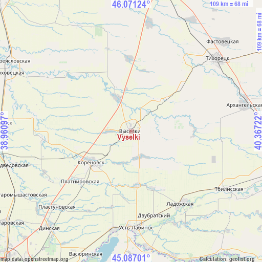
Vyselki GPS coordinates[2]
45° 34' 52.608" North, 39° 39' 50.724" East
| Map corner | latitude | longitude |
|---|---|---|
| Upper-left | 46.07124°, | 38.96097° |
| Center: | 45.58128°, | 39.66409° |
| Lower-right: | 45.08701°, | 40.36722° |
| Map W x H: | 109.4×109.4 km | = 68×68mi |
| max Lat: | 73.50819° ⇑85.1% North |
| Vyselki: | 45.58128° |
| min Lat: | ⇓14.9% South 41.28413° |
| min Long | Vyselki | max Long |
| -179.12198° | 39.66409° | 179.35046° |
| W 30.8%⇐ | ⇒69.2% E |
Elevation
Elevation of Vyselki is 59 m = 194 ft, and this is 143.6 m = 471 ft below average elevation for this country.
| Max E: |
2518 m = 8261 ft | 82.8% |
| Avg. | 202.6 m = 665 ft | |
| Vyselki | 59 m = 194 ft | |
Min E: |
-28 m = -92 ft | 17.2% |
See also: Russia elevation on elevation.city.
Geographical zone
Vyselki is located in North temperate zone (between Tropic of Cancer and the Arctic Circle). Distance of this North polar circle is 2333 km =1449.7 mi to North.| Distance of | km | miles | from Vyselki |
|---|---|---|---|
| North Pole | 4938.9 | 3068.9 | to North |
| Arctic Circle | 2333 | 1449.7 | to North |
| Tropic Cancer | 2462.2 | 1529.9 | to South |
| Equator | 5068.2 | 3149.2 | to South |


Nearby cities:
15 places around Vyselki: (largest is in red/bold)
• Alekseyevskaya
43.6 km =27.1 mi,  60°
60°
• Baturinskaya
32.7 km =20.3 mi,  315°
315°
• Berezanskaya
14.9 km =9.3 mi,  338°
338°
• Dvubratskiy
39.6 km =24.6 mi,  163°
163°
• Irkliyevskaya
30.6 km =19 mi,  358°
358°
• Khatukay
43.4 km =27 mi,  180°
180°
• Korenovsk
20.7 km =12.9 mi,  233°
233°
• Ladozhskaya
37.1 km =23.1 mi,  144°
144°
• Novobeysugskaya
21.1 km =13.1 mi,  125°
125°
• Novokorsunskaya
40.8 km =25.4 mi,  279°
279°
• Novomalorossiyskaya
18.9 km =11.7 mi,  71°
71°
• Novorozhdestvenskaya
38.2 km =23.7 mi,  35°
35°
• Plastunovskaya
44.6 km =27.7 mi,  224°
224°
• Platnirovskaya
30.1 km =18.7 mi, 226°
• Ust’-Labinsk
41.2 km =25.6 mi, 177°
Sources, notices
• [Note1] Compared only with cities in Russia existing in our database
• [Src1] Map data: © OpenStreetMap contributors (CC-BY-SA)
• [Src2] Other city data from geonames.org with taken over terms of usage.
• [Src3] Geographical zone / Annual Mean Temperature by Robert A. Rohde @ Wikipedia
