Ust’-Labinsk geodata
Ust’-Labinsk (Krasnodarskiy) is a seat of a second-order administrative division; located in Russia in Europe/Moscow (GMT+3) time zone. With population of 44,088 people, there are 473 cities with bigger population in this country. Compared to other cities in Russia, 86.4% of cities are located further ↑North; 69.1% of cities are located further →East and 78.7% of cities have higher elevation than Ust’-Labinsk. Note1


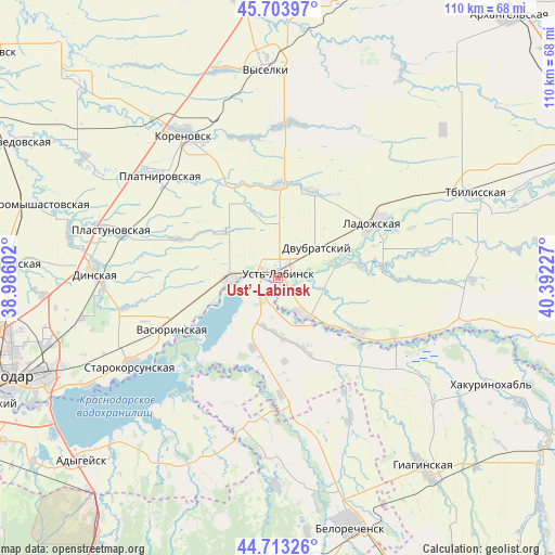
Ust’-Labinsk GPS coordinates[2]
45° 12' 38.772" North, 39° 41' 20.904" East
| Map corner | latitude | longitude |
|---|---|---|
| Upper-left | 45.70397°, | 38.98602° |
| Center: | 45.21077°, | 39.68914° |
| Lower-right: | 44.71326°, | 40.39227° |
| Map W x H: | 110.2×110.2 km | = 68.5×68.5mi |
| max Lat: | 73.50819° ⇑86.4% North |
| Ust’-Labinsk: | 45.21077° |
| min Lat: | ⇓13.6% South 41.28413° |
| min Long | Ust’-Labinsk | max Long |
| -179.12198° | 39.68914° | 179.35046° |
| W 30.9%⇐ | ⇒69.1% E |
Elevation
Elevation of Ust’-Labinsk is 75 m = 246 ft, and this is 127.6 m = 419 ft below average elevation for this country.
| Max E: |
2518 m = 8261 ft | 78.7% |
| Avg. | 202.6 m = 665 ft | |
| Ust’-Labinsk | 75 m = 246 ft | |
Min E: |
-28 m = -92 ft | 21.3% |
See also: Ust’-Labinsk elevation on elevation.city.
Geographical zone
Ust’-Labinsk is located in North temperate zone (between Tropic of Cancer and the Arctic Circle). Distance of this North polar circle is 2374.2 km =1475.3 mi to North.| Distance of | km | miles | from Ust’-Labinsk |
|---|---|---|---|
| North Pole | 4980.1 | 3094.5 | to North |
| Arctic Circle | 2374.2 | 1475.3 | to North |
| Tropic Cancer | 2421 | 1504.3 | to South |
| Equator | 5027 | 3123.6 | to South |


Nearby cities:
15 places around Ust’-Labinsk: (largest is in red/bold)
• Beloye
18.3 km =11.4 mi,  189°
189°
• Dvubratskiy
9.6 km =6 mi,  70°
70°
• Khatukay
3 km =1.9 mi,  222°
222°
• Korenovsk
34.2 km =21.3 mi,  327°
327°
• Krasnogvardeyskoye
13 km =8.1 mi, 224°
• Ladozhskaya
22.3 km =13.9 mi,  60°
60°
• Nekrasovskaya
8.7 km =5.4 mi,  147°
147°
• Novobeysugskaya
32.9 km =20.4 mi,  27°
27°
• Novolabinskaya
19.6 km =12.2 mi,  125°
125°
• Plastunovskaya
34.5 km =21.4 mi,  285°
285°
• Platnirovskaya
31.5 km =19.6 mi,  310°
310°
• Ryazanskaya
29.5 km =18.3 mi,  195°
195°
• Starokorsunskaya
33.9 km =21.1 mi,  239°
239°
• Vasyurinskaya
23.2 km =14.4 mi, 243°
• Velikovechnoye
31.2 km =19.4 mi,  170°
170°
Sources, notices
• [Note1] Compared only with cities in Russia existing in our database
• [Src1] Map data: © OpenStreetMap contributors (CC-BY-SA)
• [Src2] Other city data from geonames.org with taken over terms of usage.
• [Src3] Geographical zone / Annual Mean Temperature by Robert A. Rohde @ Wikipedia
