Vykhino-Zhulebino geodata
Vykhino-Zhulebino (Moscow) is a section of populated place; located in Russia in Europe/Moscow (GMT+3) time zone. With population of 216,000 people, there are 92 cities with bigger population in this country. Compared to other cities in Russia, 61.7% of cities are located further ↓South; 78.8% of cities are located further →East and 55.6% of cities have higher elevation than Vykhino-Zhulebino. Note1


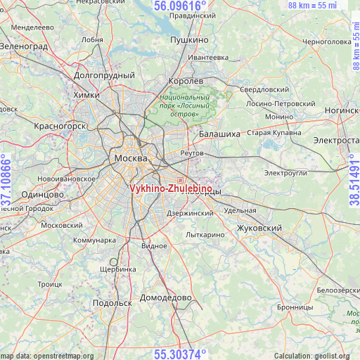
Vykhino-Zhulebino GPS coordinates[2]
55° 42' 7.056" North, 37° 48' 42.408" East
| Map corner | latitude | longitude |
|---|---|---|
| Upper-left | 56.09616°, | 37.10866° |
| Center: | 55.70196°, | 37.81178° |
| Lower-right: | 55.30374°, | 38.51491° |
| Map W x H: | 88.1×88.1 km | = 54.7×54.7mi |
| max Lat: | 73.50819° ⇑38.3% North |
| Vykhino-Zhulebino: | 55.70196° |
| min Lat: | ⇓61.7% South 41.28413° |
| min Long | Vykhino-Zhulebi | max Long |
| -179.12198° | 37.81178° | 179.35046° |
| W 21.2%⇐ | ⇒78.8% E |
Elevation
Elevation of Vykhino-Zhulebino is 133 m = 436 ft, and this is 69.6 m = 228 ft below average elevation for this country.
| Max E: |
2518 m = 8261 ft | 55.6% |
| Avg. | 202.6 m = 665 ft | |
| Vykhino-Zhulebino | 133 m = 436 ft | |
Min E: |
-28 m = -92 ft | 44.4% |
See also: Vykhino-Zhulebino elevation on elevation.city.
Geographical zone
Vykhino-Zhulebino is located in North temperate zone (between Tropic of Cancer and the Arctic Circle). Distance of this North polar circle is 1207.7 km =750.4 mi to North.| Distance of | km | miles | from Vykhino-Zhulebino |
|---|---|---|---|
| North Pole | 3813.6 | 2369.7 | to North |
| Arctic Circle | 1207.7 | 750.4 | to North |
| Tropic Cancer | 3587.6 | 2229.2 | to South |
| Equator | 6193.5 | 3848.5 | to South |


Nearby cities:
15 places around Vykhino-Zhulebino: (largest is in red/bold)
• Ivanovskoye
7.3 km =4.5 mi,  10°
10°
• Kapotnya
7.2 km =4.5 mi,  189°
189°
• Kuskovo
3.7 km =2.3 mi, 14°
• Kuz’minki
0.8 km =0.5 mi,  253°
253°
• Lyubertsy
5.8 km =3.6 mi,  118°
118°
• Lyublino
4.2 km =2.6 mi,  229°
229°
• Nekrasovka
6.3 km =3.9 mi,  98°
98°
• Novogireyevo
5.8 km =3.6 mi,  4°
4°
• Novokuz’minki
2.4 km =1.5 mi,  312°
312°
• Novyye Kuz’minki
3.9 km =2.4 mi,  266°
266°
• Reutov
7.2 km =4.5 mi,  23°
23°
• Ryazanskiy
4.5 km =2.8 mi,  320°
320°
• Tekstil’shchiki
4.3 km =2.7 mi, 267°
• Veshnyaki
2.5 km =1.6 mi, 11°
• Zhulebino
2.4 km =1.5 mi, 95°
Sources, notices
• [Note1] Compared only with cities in Russia existing in our database
• [Src1] Map data: © OpenStreetMap contributors (CC-BY-SA)
• [Src2] Other city data from geonames.org with taken over terms of usage.
• [Src3] Geographical zone / Annual Mean Temperature by Robert A. Rohde @ Wikipedia
