Veshnyaki geodata
Veshnyaki (Moscow) is a section of populated place; located in Russia in Europe/Moscow (GMT+3) time zone. With population of 122,000 people, there are 165 cities with bigger population in this country. Compared to other cities in Russia, 62.2% of cities are located further ↓South; 78.7% of cities are located further →East and 54.5% of cities have lower elevation than Veshnyaki. Note1
Administrative division(s):
- Level 1: Moscow
- Level 2: Eastern Administrative Okrug
- Level 3: Veshnyaki District


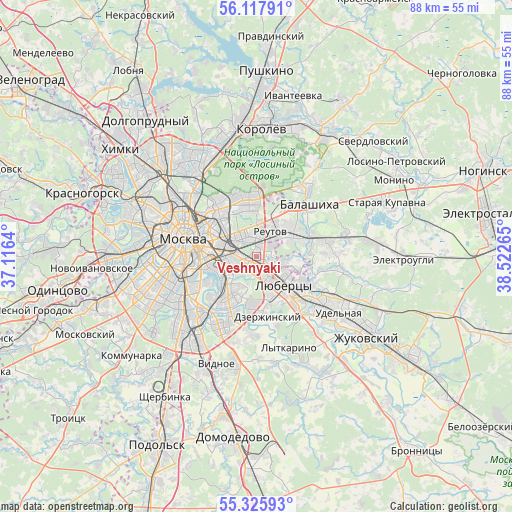
Veshnyaki GPS coordinates[2]
55° 43' 26.148" North, 37° 49' 10.272" East
| Map corner | latitude | longitude |
|---|---|---|
| Upper-left | 56.11791°, | 37.1164° |
| Center: | 55.72393°, | 37.81952° |
| Lower-right: | 55.32593°, | 38.52265° |
| Map W x H: | 88.1×88.1 km | = 54.7×54.7mi |
| max Lat: | 73.50819° ⇑37.8% North |
| Veshnyaki: | 55.72393° |
| min Lat: | ⇓62.2% South 41.28413° |
| min Long | Veshnyaki | max Long |
| -179.12198° | 37.81952° | 179.35046° |
| W 21.3%⇐ | ⇒78.7% E |
Elevation
Elevation of Veshnyaki is 155 m = 509 ft, and this is 47.6 m = 156 ft below average elevation for this country.
| Max E: |
2518 m = 8261 ft | 45.5% |
| Avg. | 202.6 m = 665 ft | |
| Veshnyaki | 155 m = 509 ft | |
Min E: |
-28 m = -92 ft | 54.5% |
See also: Veshnyaki elevation on elevation.city.
Geographical zone
Veshnyaki is located in North temperate zone (between Tropic of Cancer and the Arctic Circle). Distance of this North polar circle is 1205.3 km =748.9 mi to North.| Distance of | km | miles | from Veshnyaki |
|---|---|---|---|
| North Pole | 3811.1 | 2368.1 | to North |
| Arctic Circle | 1205.3 | 748.9 | to North |
| Tropic Cancer | 3590 | 2230.7 | to South |
| Equator | 6195.9 | 3850 | to South |


Nearby cities:
15 places around Veshnyaki: (largest is in red/bold)
• Ivanovskoye
4.8 km =3 mi,  10°
10°
• Izmaylovo
7.1 km =4.4 mi,  350°
350°
• Kuskovo
1.2 km =0.7 mi,  19°
19°
• Kuz’minki
2.9 km =1.8 mi,  204°
204°
• Lyubertsy
7 km =4.3 mi,  138°
138°
• Lyublino
6.4 km =4 mi,  215°
215°
• Nekrasovka
6.7 km =4.2 mi,  120°
120°
• Novogireyevo
3.3 km =2.1 mi,  359°
359°
• Novokuz’minki
2.4 km =1.5 mi,  250°
250°
• Novyye Kuz’minki
5.1 km =3.2 mi,  238°
238°
• Reutov
4.8 km =3 mi,  29°
29°
• Ryazanskiy
3.5 km =2.2 mi,  287°
287°
• Tekstil’shchiki
5.5 km =3.4 mi, 241°
• Vykhino-Zhulebino
2.5 km =1.6 mi,  191°
191°
• Zhulebino
3.3 km =2.1 mi, 144°
Sources, notices
• [Note1] Compared only with cities in Russia existing in our database
• [Src1] Map data: © OpenStreetMap contributors (CC-BY-SA)
• [Src2] Other city data from geonames.org with taken over terms of usage.
• [Src3] Geographical zone / Annual Mean Temperature by Robert A. Rohde @ Wikipedia
