Reutov geodata
Reutov (Moscow Oblast) is a populated place; located in Russia in Europe/Moscow (GMT+3) time zone. With population of 78,370 people, there are 265 cities with bigger population in this country. Compared to other cities in Russia, 62.9% of cities are located further ↓South; 78.4% of cities are located further →East and 59.9% of cities have lower elevation than Reutov. Note1


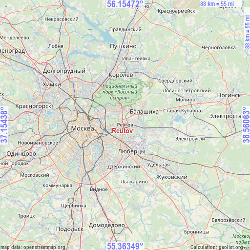
Reutov GPS coordinates[2]
55° 45' 39.996" North, 37° 51' 27" East
| Map corner | latitude | longitude |
|---|---|---|
| Upper-left | 56.15472°, | 37.15438° |
| Center: | 55.76111°, | 37.8575° |
| Lower-right: | 55.36349°, | 38.56063° |
| Map W x H: | 88×88 km | = 54.7×54.7mi |
| max Lat: | 73.50819° ⇑37.1% North |
| Reutov: | 55.76111° |
| min Lat: | ⇓62.9% South 41.28413° |
| min Long | Reutov | max Long |
| -179.12198° | 37.8575° | 179.35046° |
| W 21.6%⇐ | ⇒78.4% E |
Elevation
Elevation of Reutov is 168 m = 551 ft, and this is 34.6 m = 114 ft below average elevation for this country.
| Max E: |
2518 m = 8261 ft | 40.1% |
| Avg. | 202.6 m = 665 ft | |
| Reutov | 168 m = 551 ft | |
Min E: |
-28 m = -92 ft | 59.9% |
See also: Reutov elevation on elevation.city.
Geographical zone
Reutov is located in North temperate zone (between Tropic of Cancer and the Arctic Circle). Distance of this North polar circle is 1201.1 km =746.3 mi to North.| Distance of | km | miles | from Reutov |
|---|---|---|---|
| North Pole | 3807 | 2365.6 | to North |
| Arctic Circle | 1201.1 | 746.3 | to North |
| Tropic Cancer | 3594.1 | 2233.3 | to South |
| Equator | 6200.1 | 3852.6 | to South |


Nearby cities:
15 places around Reutov: (largest is in red/bold)
• Balashikha
8.3 km =5.2 mi,  49°
49°
• Gol’yanovo
7.4 km =4.6 mi,  338°
338°
• Ivanovskoye
1.6 km =1 mi,  292°
292°
• Izmaylovo
4.5 km =2.8 mi,  309°
309°
• Kuskovo
3.6 km =2.2 mi,  213°
213°
• Kuz’minki
7.7 km =4.8 mi, 207°
• Metrogorodok
6.9 km =4.3 mi,  320°
320°
• Novogireyevo
2.6 km =1.6 mi,  251°
251°
• Novokuz’minki
6.8 km =4.2 mi,  223°
223°
• Ryazanskiy
6.5 km =4 mi,  241°
241°
• Saltykovka
4.9 km =3 mi,  82°
82°
• Veshnyaki
4.8 km =3 mi, 209°
• Vostochnyy
6.2 km =3.9 mi,  5°
5°
• Vykhino-Zhulebino
7.2 km =4.5 mi,  203°
203°
• Zhulebino
6.8 km =4.2 mi,  183°
183°
Sources, notices
• [Note1] Compared only with cities in Russia existing in our database
• [Src1] Map data: © OpenStreetMap contributors (CC-BY-SA)
• [Src2] Other city data from geonames.org with taken over terms of usage.
• [Src3] Geographical zone / Annual Mean Temperature by Robert A. Rohde @ Wikipedia
