Ivanovskoye geodata
Ivanovskoye (Moscow) is a section of populated place; located in Russia in Europe/Moscow (GMT+3) time zone. With population of 128,000 people, there are 158 cities with bigger population in this country. Compared to other cities in Russia, 63.1% of cities are located further ↓South; 78.6% of cities are located further →East and 54.9% of cities have lower elevation than Ivanovskoye. Note1


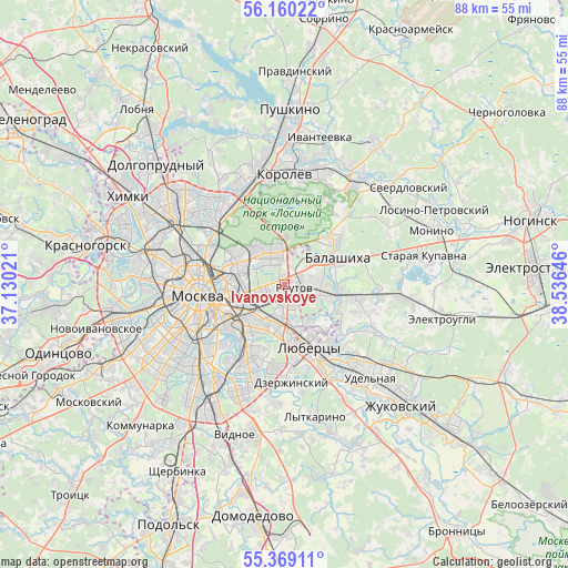
Ivanovskoye GPS coordinates[2]
55° 46' 0.012" North, 37° 49' 59.988" East
| Map corner | latitude | longitude |
|---|---|---|
| Upper-left | 56.16022°, | 37.13021° |
| Center: | 55.76667°, | 37.83333° |
| Lower-right: | 55.36911°, | 38.53646° |
| Map W x H: | 88×88 km | = 54.7×54.7mi |
| max Lat: | 73.50819° ⇑36.9% North |
| Ivanovskoye: | 55.76667° |
| min Lat: | ⇓63.1% South 41.28413° |
| min Long | Ivanovskoye | max Long |
| -179.12198° | 37.83333° | 179.35046° |
| W 21.4%⇐ | ⇒78.6% E |
Elevation
Elevation of Ivanovskoye is 156 m = 512 ft, and this is 46.6 m = 153 ft below average elevation for this country.
| Max E: |
2518 m = 8261 ft | 45.1% |
| Avg. | 202.6 m = 665 ft | |
| Ivanovskoye | 156 m = 512 ft | |
Min E: |
-28 m = -92 ft | 54.9% |
See also: Ivanovskoye elevation on elevation.city.
Geographical zone
Ivanovskoye is located in North temperate zone (between Tropic of Cancer and the Arctic Circle). Distance of this North polar circle is 1200.5 km =746 mi to North.| Distance of | km | miles | from Ivanovskoye |
|---|---|---|---|
| North Pole | 3806.4 | 2365.2 | to North |
| Arctic Circle | 1200.5 | 746 | to North |
| Tropic Cancer | 3594.8 | 2233.7 | to South |
| Equator | 6200.7 | 3852.9 | to South |


Nearby cities:
15 places around Ivanovskoye: (largest is in red/bold)
• Gol’yanovo
6.4 km =4 mi,  348°
348°
• Izmaylovo
3 km =1.9 mi,  318°
318°
• Kuskovo
3.6 km =2.2 mi,  187°
187°
• Kuz’minki
7.7 km =4.8 mi,  195°
195°
• Lefortovo
8.3 km =5.2 mi,  270°
270°
• Metrogorodok
5.6 km =3.5 mi,  328°
328°
• Novogireyevo
1.7 km =1.1 mi,  212°
212°
• Novokuz’minki
6.4 km =4 mi, 209°
• Reutov
1.6 km =1 mi,  112°
112°
• Ryazanskiy
5.6 km =3.5 mi,  228°
228°
• Saltykovka
6.4 km =4 mi,  89°
89°
• Veshnyaki
4.8 km =3 mi, 190°
• Vostochnyy
5.9 km =3.7 mi,  20°
20°
• Vykhino-Zhulebino
7.3 km =4.5 mi, 190°
• Zhulebino
7.5 km =4.7 mi,  171°
171°
Sources, notices
• [Note1] Compared only with cities in Russia existing in our database
• [Src1] Map data: © OpenStreetMap contributors (CC-BY-SA)
• [Src2] Other city data from geonames.org with taken over terms of usage.
• [Src3] Geographical zone / Annual Mean Temperature by Robert A. Rohde @ Wikipedia
