Vozhd’ Proletariata geodata
Vozhd’ Proletariata (Moscow Oblast) is a populated place; located in Russia in Europe/Moscow (GMT+3) time zone. With population of 594 people, there are 4901 cities with bigger population in this country. Compared to other cities in Russia, 57.5% of cities are located further ↓South; 70.9% of cities are located further →East and 57.7% of cities have higher elevation than Vozhd’ Proletariata. Note1


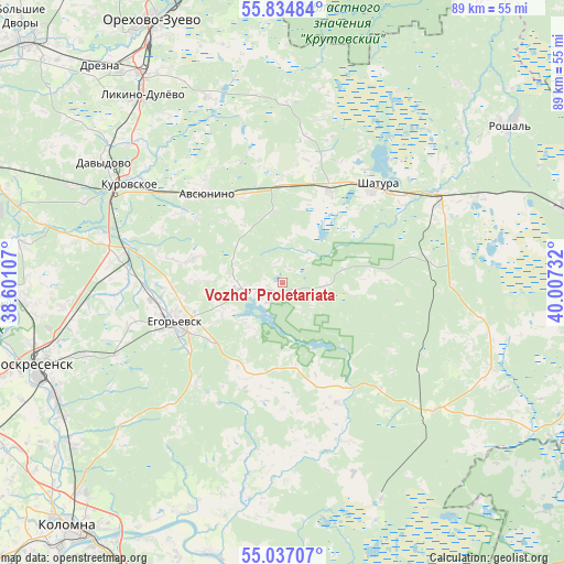
Vozhd’ Proletariata GPS coordinates[2]
55° 26' 16.692" North, 39° 18' 15.084" East
| Map corner | latitude | longitude |
|---|---|---|
| Upper-left | 55.83484°, | 38.60107° |
| Center: | 55.43797°, | 39.30419° |
| Lower-right: | 55.03707°, | 40.00732° |
| Map W x H: | 88.7×88.7 km | = 55.1×55.1mi |
| max Lat: | 73.50819° ⇑42.5% North |
| Vozhd’ Proletariata: | 55.43797° |
| min Lat: | ⇓57.5% South 41.28413° |
| min Long | Vozhd’ Prolet | max Long |
| -179.12198° | 39.30419° | 179.35046° |
| W 29.1%⇐ | ⇒70.9% E |
Elevation
Elevation of Vozhd’ Proletariata is 129 m = 423 ft, and this is 73.6 m = 241 ft below average elevation for this country.
| Max E: |
2518 m = 8261 ft | 57.7% |
| Avg. | 202.6 m = 665 ft | |
| Vozhd’ Proletariata | 129 m = 423 ft | |
Min E: |
-28 m = -92 ft | 42.3% |
See also: Russia elevation on elevation.city.
Geographical zone
Vozhd’ Proletariata is located in North temperate zone (between Tropic of Cancer and the Arctic Circle). Distance of this North polar circle is 1237 km =768.6 mi to North.| Distance of | km | miles | from Vozhd’ Proletariata |
|---|---|---|---|
| North Pole | 3842.9 | 2387.9 | to North |
| Arctic Circle | 1237 | 768.6 | to North |
| Tropic Cancer | 3558.2 | 2211 | to South |
| Equator | 6164.1 | 3830.2 | to South |


Nearby cities:
15 places around Vozhd’ Proletariata: (largest is in red/bold)
• Avsyunino
18.2 km =11.3 mi,  321°
321°
• Davydovo
33.7 km =20.9 mi,  304°
304°
• Fosforitnyy
28.5 km =17.7 mi,  244°
244°
• Il’inskiy Pogost
25.3 km =15.7 mi,  280°
280°
• Kerva
25.8 km =16 mi,  41°
41°
• Khorlovo
33.1 km =20.6 mi,  249°
249°
• Krasnyy Tkach
14.6 km =9.1 mi,  285°
285°
• Kurovskoye
29 km =18 mi, 303°
• Novoye
32.3 km =20.1 mi,  311°
311°
• Sel’nikovo
34.8 km =21.6 mi,  195°
195°
• Shatura
20.9 km =13 mi, 44°
• Shaturtorf
16.1 km =10 mi,  27°
27°
• Tugolesskiy Bor
35.1 km =21.8 mi,  69°
69°
• Yegor’yevsk
18.2 km =11.3 mi, 250°
• Yurtsovo
15 km =9.3 mi,  207°
207°
Sources, notices
• [Note1] Compared only with cities in Russia existing in our database
• [Src1] Map data: © OpenStreetMap contributors (CC-BY-SA)
• [Src2] Other city data from geonames.org with taken over terms of usage.
• [Src3] Geographical zone / Annual Mean Temperature by Robert A. Rohde @ Wikipedia
