Tugolesskiy Bor geodata
Tugolesskiy Bor (Moscow Oblast) is a populated place; located in Russia in Europe/Moscow (GMT+3) time zone. With population of 2,217 people, there are 4064 cities with bigger population in this country. Compared to other cities in Russia, 58.7% of cities are located further ↓South; 68.5% of cities are located further →East and 62% of cities have higher elevation than Tugolesskiy Bor. Note1


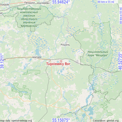
Tugolesskiy Bor GPS coordinates[2]
55° 33' 1.836" North, 39° 49' 27.192" East
| Map corner | latitude | longitude |
|---|---|---|
| Upper-left | 55.94624°, | 39.1211° |
| Center: | 55.55051°, | 39.82422° |
| Lower-right: | 55.15075°, | 40.52735° |
| Map W x H: | 88.5×88.4 km | = 55×54.9mi |
| max Lat: | 73.50819° ⇑41.3% North |
| Tugolesskiy Bor: | 55.55051° |
| min Lat: | ⇓58.7% South 41.28413° |
| min Long | Tugolesskiy Bor | max Long |
| -179.12198° | 39.82422° | 179.35046° |
| W 31.5%⇐ | ⇒68.5% E |
Elevation
Elevation of Tugolesskiy Bor is 120 m = 394 ft, and this is 82.6 m = 271 ft below average elevation for this country.
| Max E: |
2518 m = 8261 ft | 62% |
| Avg. | 202.6 m = 665 ft | |
| Tugolesskiy Bor | 120 m = 394 ft | |
Min E: |
-28 m = -92 ft | 38% |
See also: Russia elevation on elevation.city.
Geographical zone
Tugolesskiy Bor is located in North temperate zone (between Tropic of Cancer and the Arctic Circle). Distance of this North polar circle is 1224.5 km =760.9 mi to North.| Distance of | km | miles | from Tugolesskiy Bor |
|---|---|---|---|
| North Pole | 3830.4 | 2380.1 | to North |
| Arctic Circle | 1224.5 | 760.9 | to North |
| Tropic Cancer | 3570.7 | 2218.7 | to South |
| Equator | 6176.6 | 3838 | to South |


Nearby cities:
15 places around Tugolesskiy Bor: (largest is in red/bold)
• Avsyunino
44.1 km =27.4 mi,  272°
272°
• Baksheyevo
17.9 km =11.1 mi,  10°
10°
• Cherusti
11.7 km =7.3 mi,  90°
90°
• Dmitrovskiy Pogost
26.4 km =16.4 mi,  178°
178°
• Erleks
35.7 km =22.2 mi,  80°
80°
• Kerva
17 km =10.6 mi,  293°
293°
• Kurlovo
43.7 km =27.2 mi,  107°
107°
• Mezinovskiy
34.1 km =21.2 mi,  98°
98°
• Misheronskiy
19.5 km =12.1 mi,  343°
343°
• Roshal’
13.5 km =8.4 mi, 13°
• Savinskaya
22.7 km =14.1 mi,  152°
152°
• Shatura
18.2 km =11.3 mi,  277°
277°
• Shaturtorf
25.4 km =15.8 mi, 274°
• Urshel’skiy
28.5 km =17.7 mi,  60°
60°
• Vozhd’ Proletariata
35.1 km =21.8 mi,  249°
249°
Sources, notices
• [Note1] Compared only with cities in Russia existing in our database
• [Src1] Map data: © OpenStreetMap contributors (CC-BY-SA)
• [Src2] Other city data from geonames.org with taken over terms of usage.
• [Src3] Geographical zone / Annual Mean Temperature by Robert A. Rohde @ Wikipedia
