Ivnya geodata
Ivnya (Belgorod Oblast) is a populated place; located in Russia in Europe/Moscow (GMT+3) time zone. With population of 7,824 people, there are 1847 cities with bigger population in this country. Compared to other cities in Russia, 74.7% of cities are located further ↑North; 87% of cities are located further →East and 76.1% of cities have lower elevation than Ivnya. Note1


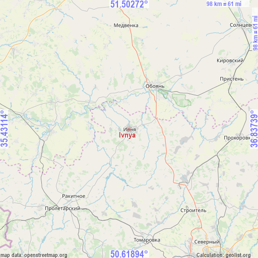
Ivnya GPS coordinates[2]
51° 3' 46.584" North, 36° 8' 3.336" East
| Map corner | latitude | longitude |
|---|---|---|
| Upper-left | 51.50272°, | 35.43114° |
| Center: | 51.06294°, | 36.13426° |
| Lower-right: | 50.61894°, | 36.83739° |
| Map W x H: | 98.3×98.3 km | = 61.1×61.1mi |
| max Lat: | 73.50819° ⇑74.7% North |
| Ivnya: | 51.06294° |
| min Lat: | ⇓25.3% South 41.28413° |
| min Long | Ivnya | max Long |
| -179.12198° | 36.13426° | 179.35046° |
| W 13%⇐ | ⇒87% E |
Elevation
Elevation of Ivnya is 221 m = 725 ft, and this is 18.4 m = 60 ft above average elevation for this country.
| Max E: |
2518 m = 8261 ft | 23.9% |
| Ivnya | 221 m 725 ft | |
| Avg. | 202.6 m = 665 ft | |
Min E: |
-28 m = -92 ft | 76.1% |
See also: Russia elevation on elevation.city.
Geographical zone
Ivnya is located in North temperate zone (between Tropic of Cancer and the Arctic Circle). Distance of this North polar circle is 1723.5 km =1070.9 mi to North.| Distance of | km | miles | from Ivnya |
|---|---|---|---|
| North Pole | 4329.4 | 2690.2 | to North |
| Arctic Circle | 1723.5 | 1070.9 | to North |
| Tropic Cancer | 3071.7 | 1908.7 | to South |
| Equator | 5677.7 | 3528 | to South |


Nearby cities:
15 places around Ivnya: (largest is in red/bold)
• Belaya
29.2 km =18.1 mi,  268°
268°
• Borisovka
52 km =32.3 mi,  189°
189°
• Chernitsyno
49.8 km =30.9 mi,  353°
353°
• Kirovskiy
54 km =33.6 mi,  43°
43°
• Krasnaya Yaruga
44.3 km =27.5 mi,  228°
228°
• Oboyan’
19.2 km =11.9 mi,  31°
31°
• Pristen’
43.6 km =27.1 mi,  63°
63°
• Prokhorovka
41.9 km =26 mi,  93°
93°
• Proletarskiy
39.4 km =24.5 mi,  219°
219°
• Rakitnoye
31.8 km =19.8 mi, 218°
• Severnyy
52 km =32.3 mi,  145°
145°
• Solntsevo
58.3 km =36.2 mi,  47°
47°
• Stroitel’
39.4 km =24.5 mi,  141°
141°
• Tomarovka
42.8 km =26.6 mi,  170°
170°
• Yakovlevo
31.5 km =19.6 mi, 135°
Sources, notices
• [Note1] Compared only with cities in Russia existing in our database
• [Src1] Map data: © OpenStreetMap contributors (CC-BY-SA)
• [Src2] Other city data from geonames.org with taken over terms of usage.
• [Src3] Geographical zone / Annual Mean Temperature by Robert A. Rohde @ Wikipedia
