Solntsevo geodata
Solntsevo (Kursk) is a populated place; located in Russia in Europe/Moscow (GMT+3) time zone. With population of 4,374 people, there are 2922 cities with bigger population in this country. Compared to other cities in Russia, 72.9% of cities are located further ↑North; 85.5% of cities are located further →East and 60.6% of cities have lower elevation than Solntsevo. Note1


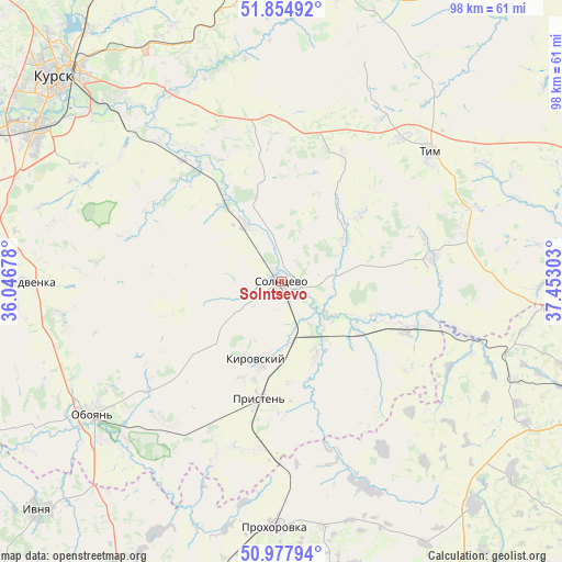
Solntsevo GPS coordinates[2]
51° 25' 6.708" North, 36° 44' 59.64" East
| Map corner | latitude | longitude |
|---|---|---|
| Upper-left | 51.85492°, | 36.04678° |
| Center: | 51.41853°, | 36.7499° |
| Lower-right: | 50.97794°, | 37.45303° |
| Map W x H: | 97.5×97.5 km | = 60.6×60.6mi |
| max Lat: | 73.50819° ⇑72.9% North |
| Solntsevo: | 51.41853° |
| min Lat: | ⇓27.1% South 41.28413° |
| min Long | Solntsevo | max Long |
| -179.12198° | 36.7499° | 179.35046° |
| W 14.5%⇐ | ⇒85.5% E |
Elevation
Elevation of Solntsevo is 170 m = 558 ft, and this is 32.6 m = 107 ft below average elevation for this country.
| Max E: |
2518 m = 8261 ft | 39.4% |
| Avg. | 202.6 m = 665 ft | |
| Solntsevo | 170 m = 558 ft | |
Min E: |
-28 m = -92 ft | 60.6% |
See also: Russia elevation on elevation.city.
Geographical zone
Solntsevo is located in North temperate zone (between Tropic of Cancer and the Arctic Circle). Distance of this North polar circle is 1684 km =1046.4 mi to North.| Distance of | km | miles | from Solntsevo |
|---|---|---|---|
| North Pole | 4289.9 | 2665.6 | to North |
| Arctic Circle | 1684 | 1046.4 | to North |
| Tropic Cancer | 3111.3 | 1933.3 | to South |
| Equator | 5717.2 | 3552.5 | to South |


Nearby cities:
15 places around Solntsevo: (largest is in red/bold)
• Chernitsyno
49.4 km =30.7 mi,  281°
281°
• Gubkin
57.3 km =35.6 mi,  105°
105°
• Ivnya
58.3 km =36.2 mi,  227°
227°
• Kirovskiy
5.8 km =3.6 mi,  267°
267°
• Kursk
52.6 km =32.7 mi,  312°
312°
• Manturovo
26.5 km =16.5 mi,  81°
81°
• Oboyan’
40.1 km =24.9 mi, 234°
• Pristen’
20.7 km =12.9 mi,  190°
190°
• Prokhorovka
42.4 km =26.3 mi,  181°
181°
• Pryamitsyno
62.5 km =38.8 mi,  295°
295°
• Shchigry
51.9 km =32.2 mi,  11°
11°
• Skorodnoye
51 km =31.7 mi,  139°
139°
• Tim
34.4 km =21.4 mi,  48°
48°
• Troitskiy
54.2 km =33.7 mi,  97°
97°
• Voroshnëvo
57 km =35.4 mi, 297°
Sources, notices
• [Note1] Compared only with cities in Russia existing in our database
• [Src1] Map data: © OpenStreetMap contributors (CC-BY-SA)
• [Src2] Other city data from geonames.org with taken over terms of usage.
• [Src3] Geographical zone / Annual Mean Temperature by Robert A. Rohde @ Wikipedia
