Verkhnyaya Khava geodata
Verkhnyaya Khava (Voronezj) is a populated place; located in Russia in Europe/Moscow (GMT+3) time zone. With population of 7,870 people, there are 1835 cities with bigger population in this country. Compared to other cities in Russia, 70.2% of cities are located further ↑North; 67.8% of cities are located further →East and 51.5% of cities have lower elevation than Verkhnyaya Khava. Note1


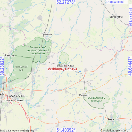
Verkhnyaya Khava GPS coordinates[2]
51° 50' 25.62" North, 39° 56' 28.824" East
| Map corner | latitude | longitude |
|---|---|---|
| Upper-left | 52.27278°, | 39.23822° |
| Center: | 51.84045°, | 39.94134° |
| Lower-right: | 51.40392°, | 40.64447° |
| Map W x H: | 96.6×96.6 km | = 60×60mi |
| max Lat: | 73.50819° ⇑70.2% North |
| Verkhnyaya Khava: | 51.84045° |
| min Lat: | ⇓29.8% South 41.28413° |
| min Long | Verkhnyaya Khav | max Long |
| -179.12198° | 39.94134° | 179.35046° |
| W 32.2%⇐ | ⇒67.8% E |
Elevation
Elevation of Verkhnyaya Khava is 148 m = 486 ft, and this is 54.6 m = 179 ft below average elevation for this country.
| Max E: |
2518 m = 8261 ft | 48.5% |
| Avg. | 202.6 m = 665 ft | |
| Verkhnyaya Khava | 148 m = 486 ft | |
Min E: |
-28 m = -92 ft | 51.5% |
See also: Russia elevation on elevation.city.
Geographical zone
Verkhnyaya Khava is located in North temperate zone (between Tropic of Cancer and the Arctic Circle). Distance of this North polar circle is 1637.1 km =1017.2 mi to North.| Distance of | km | miles | from Verkhnyaya Khava |
|---|---|---|---|
| North Pole | 4242.9 | 2636.4 | to North |
| Arctic Circle | 1637.1 | 1017.2 | to North |
| Tropic Cancer | 3158.2 | 1962.4 | to South |
| Equator | 5764.1 | 3581.6 | to South |


Nearby cities:
15 places around Verkhnyaya Khava: (largest is in red/bold)
• Dobrinka
51.3 km =31.9 mi,  45°
45°
• Krasnolesnyy
24.7 km =15.3 mi,  280°
280°
• Novaya Usman’
42.8 km =26.6 mi,  238°
238°
• Orlovo
26.2 km =16.3 mi,  248°
248°
• Panino
25.3 km =15.7 mi,  148°
148°
• Pereleshino
17.8 km =11.1 mi,  130°
130°
• Pereleshinskiy
22.4 km =13.9 mi, 128°
• Podkletnoye
43.2 km =26.8 mi,  229°
229°
• Prigorodka
27.6 km =17.1 mi,  325°
325°
• Ramon’
42.4 km =26.3 mi, 281°
• Sadovoye
51.7 km =32.1 mi, 131°
• Somovo
41 km =25.5 mi, 254°
• Uglyanets
23.8 km =14.8 mi,  264°
264°
• Usman’
27.2 km =16.9 mi, 327°
• Volya
28.8 km =17.9 mi, 253°
Sources, notices
• [Note1] Compared only with cities in Russia existing in our database
• [Src1] Map data: © OpenStreetMap contributors (CC-BY-SA)
• [Src2] Other city data from geonames.org with taken over terms of usage.
• [Src3] Geographical zone / Annual Mean Temperature by Robert A. Rohde @ Wikipedia
