Ugra geodata
Ugra (Smolensk) is a populated place; located in Russia in Europe/Moscow (GMT+3) time zone. With population of 4,721 people, there are 2773 cities with bigger population in this country. Compared to other cities in Russia, 51.1% of cities are located further ↓South; 90% of cities are located further →East and 72.3% of cities have lower elevation than Ugra. Note1


Ugra GPS coordinates[2]
54° 46' 39.9" North, 34° 19' 36.264" East
| Map corner | latitude | longitude |
|---|---|---|
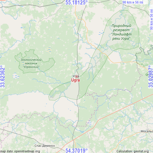
| Upper-left | 55.18125°, | 33.62362° |
| Center: | 54.77775°, | 34.32674° |
| Lower-right: | 54.37019°, | 35.02987° |
| Map W x H: | 90.2×90.2 km | = 56×56mi |
| max Lat: | 73.50819° ⇑48.9% North |
| Ugra: | 54.77775° |
| min Lat: | ⇓51.1% South 41.28413° |
| min Long | Ugra | max Long |
| -179.12198° | 34.32674° | 179.35046° |
| W 10%⇐ | ⇒90% E |
Elevation
Elevation of Ugra is 206 m = 676 ft, and this is 3.4 m = 11 ft above average elevation for this country.
| Max E: |
2518 m = 8261 ft | 27.7% |
| Ugra | 206 m 676 ft | |
| Avg. | 202.6 m = 665 ft | |
Min E: |
-28 m = -92 ft | 72.3% |
See also: Russia elevation on elevation.city.
Geographical zone
Ugra is located in North temperate zone (between Tropic of Cancer and the Arctic Circle). Distance of this North polar circle is 1310.5 km =814.3 mi to North.| Distance of | km | miles | from Ugra |
|---|---|---|---|
| North Pole | 3916.3 | 2433.5 | to North |
| Arctic Circle | 1310.5 | 814.3 | to North |
| Tropic Cancer | 3484.8 | 2165.4 | to South |
| Equator | 6090.7 | 3784.6 | to South |


Nearby cities:
15 places around Ugra: (largest is in red/bold)
• Baryatino
53.3 km =33.1 mi,  166°
166°
• Dorogobuzh
67.7 km =42.1 mi,  283°
283°
• Iznoski
67.1 km =41.7 mi,  69°
69°
• Kirov
79.1 km =49.2 mi,  181°
181°
• Meshchovsk
79.5 km =49.4 mi,  129°
129°
• Mosal’sk
53 km =32.9 mi, 127°
• Myatlevo
87.4 km =54.3 mi,  81°
81°
• Nikola-Lenivets
81.8 km =50.8 mi,  92°
92°
• Safonovo
79.1 km =49.2 mi,  297°
297°
• Spas-Demensk
45.1 km =28 mi,  205°
205°
• Tëmkino
57.3 km =35.6 mi,  49°
49°
• Verkhnedneprovskiy
66.7 km =41.4 mi,  289°
289°
• Vyaz’ma
48.1 km =29.9 mi,  357°
357°
• Yel’nya
76.7 km =47.7 mi,  253°
253°
• Yukhnov
58 km =36 mi, 93°
Sources, notices
• [Note1] Compared only with cities in Russia existing in our database
• [Src1] Map data: © OpenStreetMap contributors (CC-BY-SA)
• [Src2] Other city data from geonames.org with taken over terms of usage.
• [Src3] Geographical zone / Annual Mean Temperature by Robert A. Rohde @ Wikipedia
