Safonovo geodata
Safonovo (Smolensk) is a seat of a second-order administrative division; located in Russia in Europe/Moscow (GMT+3) time zone. With population of 46,000 people, there are 457 cities with bigger population in this country. Compared to other cities in Russia, 54.5% of cities are located further ↓South; 91.8% of cities are located further →East and 75% of cities have lower elevation than Safonovo. Note1


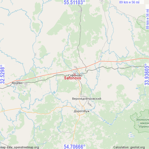
Safonovo GPS coordinates[2]
55° 6' 39.132" North, 33° 13' 58.512" East
| Map corner | latitude | longitude |
|---|---|---|
| Upper-left | 55.51103°, | 32.5298° |
| Center: | 55.11087°, | 33.23292° |
| Lower-right: | 54.70666°, | 33.93605° |
| Map W x H: | 89.4×89.4 km | = 55.6×55.6mi |
| max Lat: | 73.50819° ⇑45.5% North |
| Safonovo: | 55.11087° |
| min Lat: | ⇓54.5% South 41.28413° |
| min Long | Safonovo | max Long |
| -179.12198° | 33.23292° | 179.35046° |
| W 8.2%⇐ | ⇒91.8% E |
Elevation
Elevation of Safonovo is 217 m = 712 ft, and this is 14.4 m = 47 ft above average elevation for this country.
| Max E: |
2518 m = 8261 ft | 25% |
| Safonovo | 217 m 712 ft | |
| Avg. | 202.6 m = 665 ft | |
Min E: |
-28 m = -92 ft | 75% |
See also: Safonovo elevation on elevation.city.
Geographical zone
Safonovo is located in North temperate zone (between Tropic of Cancer and the Arctic Circle). Distance of this North polar circle is 1273.4 km =791.3 mi to North.| Distance of | km | miles | from Safonovo |
|---|---|---|---|
| North Pole | 3879.3 | 2410.5 | to North |
| Arctic Circle | 1273.4 | 791.3 | to North |
| Tropic Cancer | 3521.8 | 2188.3 | to South |
| Equator | 6127.8 | 3807.6 | to South |


Nearby cities:
15 places around Safonovo: (largest is in red/bold)
• Belyy
83.1 km =51.6 mi,  347°
347°
• Dorogobuzh
22.2 km =13.8 mi,  169°
169°
• Dukhovshchina
53 km =32.9 mi,  279°
279°
• Glinka
57 km =35.4 mi,  203°
203°
• Kardymovo
56.7 km =35.2 mi,  244°
244°
• Kholm-Zhirkovskiy
47.8 km =29.7 mi,  18°
18°
• Ozërnyy
73.6 km =45.7 mi,  315°
315°
• Pechersk
81.8 km =50.8 mi,  249°
249°
• Smolensk
84.5 km =52.5 mi, 244°
• Talashkino
84.1 km =52.3 mi,  232°
232°
• Ugra
79.1 km =49.2 mi,  117°
117°
• Verkhnedneprovskiy
16.1 km =10 mi,  153°
153°
• Vyaz’ma
68.4 km =42.5 mi,  80°
80°
• Yartsevo
34.5 km =21.4 mi,  261°
261°
• Yel’nya
59.3 km =36.8 mi,  183°
183°
Sources, notices
• [Note1] Compared only with cities in Russia existing in our database
• [Src1] Map data: © OpenStreetMap contributors (CC-BY-SA)
• [Src2] Other city data from geonames.org with taken over terms of usage.
• [Src3] Geographical zone / Annual Mean Temperature by Robert A. Rohde @ Wikipedia
