Vyaz’ma geodata
Vyaz’ma (Smolensk) is a populated place; located in Russia in Europe/Moscow (GMT+3) time zone. With population of 55,500 people, there are 376 cities with bigger population in this country. Compared to other cities in Russia, 55.4% of cities are located further ↓South; 90.1% of cities are located further →East and 79.8% of cities have lower elevation than Vyaz’ma. Note1


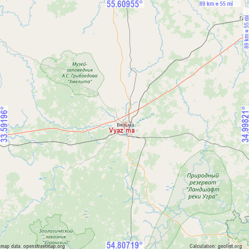
Vyaz’ma GPS coordinates[2]
55° 12' 37.404" North, 34° 17' 42.288" East
| Map corner | latitude | longitude |
|---|---|---|
| Upper-left | 55.60955°, | 33.59196° |
| Center: | 55.21039°, | 34.29508° |
| Lower-right: | 54.80719°, | 34.99821° |
| Map W x H: | 89.2×89.2 km | = 55.4×55.4mi |
| max Lat: | 73.50819° ⇑44.6% North |
| Vyaz’ma: | 55.21039° |
| min Lat: | ⇓55.4% South 41.28413° |
| min Long | Vyaz’ma | max Long |
| -179.12198° | 34.29508° | 179.35046° |
| W 9.9%⇐ | ⇒90.1% E |
Elevation
Elevation of Vyaz’ma is 246 m = 807 ft, and this is 43.4 m = 142 ft above average elevation for this country.
| Max E: |
2518 m = 8261 ft | 20.2% |
| Vyaz’ma | 246 m 807 ft | |
| Avg. | 202.6 m = 665 ft | |
Min E: |
-28 m = -92 ft | 79.8% |
See also: Vyaz’ma elevation on elevation.city.
Geographical zone
Vyaz’ma is located in North temperate zone (between Tropic of Cancer and the Arctic Circle). Distance of this North polar circle is 1262.4 km =784.4 mi to North.| Distance of | km | miles | from Vyaz’ma |
|---|---|---|---|
| North Pole | 3868.2 | 2403.6 | to North |
| Arctic Circle | 1262.4 | 784.4 | to North |
| Tropic Cancer | 3532.9 | 2195.2 | to South |
| Equator | 6138.8 | 3814.5 | to South |


Nearby cities:
15 places around Vyaz’ma: (largest is in red/bold)
• Dorogobuzh
71.5 km =44.4 mi,  242°
242°
• Gagarin
58.4 km =36.3 mi,  49°
49°
• Iznoski
69.2 km =43 mi,  110°
110°
• Kholm-Zhirkovskiy
62.3 km =38.7 mi,  303°
303°
• Mosal’sk
91.6 km =56.9 mi,  151°
151°
• Myatlevo
94.6 km =58.8 mi, 111°
• Novodugino
46.7 km =29 mi,  359°
359°
• Safonovo
68.4 km =42.5 mi,  260°
260°
• Spas-Demensk
90.4 km =56.2 mi,  191°
191°
• Sychëvka
68.4 km =42.5 mi, 358°
• Tëmkino
47 km =29.2 mi,  103°
103°
• Ugra
48.1 km =29.9 mi,  177°
177°
• Uvarovka
90 km =55.9 mi,  66°
66°
• Verkhnedneprovskiy
65.6 km =40.8 mi,  247°
247°
• Yukhnov
79 km =49.1 mi,  130°
130°
Sources, notices
• [Note1] Compared only with cities in Russia existing in our database
• [Src1] Map data: © OpenStreetMap contributors (CC-BY-SA)
• [Src2] Other city data from geonames.org with taken over terms of usage.
• [Src3] Geographical zone / Annual Mean Temperature by Robert A. Rohde @ Wikipedia
