Levashevo geodata
Levashevo (Jaroslavl) is a populated place; located in Russia in Europe/Moscow (GMT+3) time zone. With population of 1,204 people, there are 4514 cities with bigger population in this country. Compared to other cities in Russia, 80.7% of cities are located further ↓South; 64.9% of cities are located further →East and 58.2% of cities have higher elevation than Levashevo. Note1


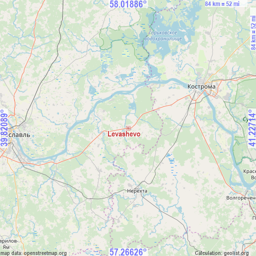
Levashevo GPS coordinates[2]
57° 38' 40.236" North, 40° 31' 26.436" East
| Map corner | latitude | longitude |
|---|---|---|
| Upper-left | 58.01886°, | 39.82089° |
| Center: | 57.64451°, | 40.52401° |
| Lower-right: | 57.26626°, | 41.22714° |
| Map W x H: | 83.7×83.7 km | = 52×52mi |
| max Lat: | 73.50819° ⇑19.3% North |
| Levashevo: | 57.64451° |
| min Lat: | ⇓80.7% South 41.28413° |
| min Long | Levashevo | max Long |
| -179.12198° | 40.52401° | 179.35046° |
| W 35.1%⇐ | ⇒64.9% E |
Elevation
Elevation of Levashevo is 128 m = 420 ft, and this is 74.6 m = 245 ft below average elevation for this country.
| Max E: |
2518 m = 8261 ft | 58.2% |
| Avg. | 202.6 m = 665 ft | |
| Levashevo | 128 m = 420 ft | |
Min E: |
-28 m = -92 ft | 41.8% |
See also: Russia elevation on elevation.city.
Geographical zone
Levashevo is located in North temperate zone (between Tropic of Cancer and the Arctic Circle). Distance of this North polar circle is 991.7 km =616.2 mi to North.| Distance of | km | miles | from Levashevo |
|---|---|---|---|
| North Pole | 3597.6 | 2235.4 | to North |
| Arctic Circle | 991.7 | 616.2 | to North |
| Tropic Cancer | 3803.5 | 2363.4 | to South |
| Equator | 6409.5 | 3982.7 | to South |


Nearby cities:
15 places around Levashevo: (largest is in red/bold)
• Burmakino
30.6 km =19 mi,  214°
214°
• Dubki
41.7 km =25.9 mi,  203°
203°
• Dulyapino
46.4 km =28.8 mi,  157°
157°
• Kosmynino
15.9 km =9.9 mi,  115°
115°
• Kostroma
27.5 km =17.1 mi,  60°
60°
• Krasnoye-na-Volge
45 km =28 mi,  108°
108°
• Krasnyy Profintern
12.3 km =7.6 mi,  334°
334°
• Krasnyye Tkachi
48.8 km =30.3 mi,  249°
249°
• Nagornyy
41.9 km =26 mi,  257°
257°
• Nekrasovskoye
10.1 km =6.3 mi,  290°
290°
• Nerekhta
20.9 km =13 mi,  171°
171°
• Oktyabr’skiy
30.5 km =19 mi,  68°
68°
• Tunoshna
26.2 km =16.3 mi, 245°
• Volgorechensk
44.1 km =27.4 mi, 121°
• Yaroslavl
38.7 km =24 mi,  267°
267°
Sources, notices
• [Note1] Compared only with cities in Russia existing in our database
• [Src1] Map data: © OpenStreetMap contributors (CC-BY-SA)
• [Src2] Other city data from geonames.org with taken over terms of usage.
• [Src3] Geographical zone / Annual Mean Temperature by Robert A. Rohde @ Wikipedia
