Giaginskaya geodata
Giaginskaya (Adygeya Republic) is a populated place; located in Russia in Europe/Moscow (GMT+3) time zone. With population of 15,169 people, there are 1086 cities with bigger population in this country. Compared to other cities in Russia, 87.9% of cities are located further ↑North; 67.2% of cities are located further →East and 57.7% of cities have higher elevation than Giaginskaya. Note1


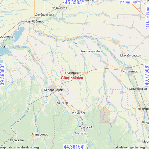
Giaginskaya GPS coordinates[2]
44° 51' 43.488" North, 40° 4' 19.02" East
| Map corner | latitude | longitude |
|---|---|---|
| Upper-left | 45.3583°, | 39.36883° |
| Center: | 44.86208°, | 40.07195° |
| Lower-right: | 44.36154°, | 40.77508° |
| Map W x H: | 110.8×110.8 km | = 68.8×68.8mi |
| max Lat: | 73.50819° ⇑87.9% North |
| Giaginskaya: | 44.86208° |
| min Lat: | ⇓12.1% South 41.28413° |
| min Long | Giaginskaya | max Long |
| -179.12198° | 40.07195° | 179.35046° |
| W 32.8%⇐ | ⇒67.2% E |
Elevation
Elevation of Giaginskaya is 129 m = 423 ft, and this is 73.6 m = 241 ft below average elevation for this country.
| Max E: |
2518 m = 8261 ft | 57.7% |
| Avg. | 202.6 m = 665 ft | |
| Giaginskaya | 129 m = 423 ft | |
Min E: |
-28 m = -92 ft | 42.3% |
See also: Russia elevation on elevation.city.
Geographical zone
Giaginskaya is located in North temperate zone (between Tropic of Cancer and the Arctic Circle). Distance of this Northern Tropic circle is 2382.3 km =1480.3 mi to South.| Distance of | km | miles | from Giaginskaya |
|---|---|---|---|
| North Pole | 5018.9 | 3118.6 | to North |
| Arctic Circle | 2413 | 1499.4 | to North |
| Tropic Cancer | 2382.3 | 1480.3 | to South |
| Equator | 4988.2 | 3099.5 | to South |


Nearby cities:
15 places around Giaginskaya: (largest is in red/bold)
• Belorechensk
18.3 km =11.4 mi,  236°
236°
• Blechepsin
34.1 km =21.2 mi,  97°
97°
• Dondukovskaya
23 km =14.3 mi,  84°
84°
• Khanskaya
22.3 km =13.9 mi,  202°
202°
• Koshekhabl’
34.9 km =21.7 mi, 83°
• Kuzhorskaya
28 km =17.4 mi,  137°
137°
• Maykop
28.4 km =17.6 mi,  174°
174°
• Novolabinskaya
30.9 km =19.2 mi,  333°
333°
• Petropavlovskaya
38.6 km =24 mi,  50°
50°
• Pshekhskaya
28.5 km =17.7 mi,  229°
229°
• Shovgenovskiy
20.4 km =12.7 mi,  36°
36°
• Temirgoyevskaya
32.5 km =20.2 mi,  30°
30°
• Velikovechnoye
26.2 km =16.3 mi,  287°
287°
• Yuzhnyy
21.8 km =13.5 mi,  224°
224°
• Yuzhnyy
35.3 km =21.9 mi,  63°
63°
Sources, notices
• [Note1] Compared only with cities in Russia existing in our database
• [Src1] Map data: © OpenStreetMap contributors (CC-BY-SA)
• [Src2] Other city data from geonames.org with taken over terms of usage.
• [Src3] Geographical zone / Annual Mean Temperature by Robert A. Rohde @ Wikipedia
