Tamala geodata
Tamala (Penza) is a populated place; located in Russia in Europe/Moscow (GMT+3) time zone. With population of 7,956 people, there are 1814 cities with bigger population in this country. Compared to other cities in Russia, 65.9% of cities are located further ↑North; 55.6% of cities are located further →East and 72.6% of cities have lower elevation than Tamala. Note1


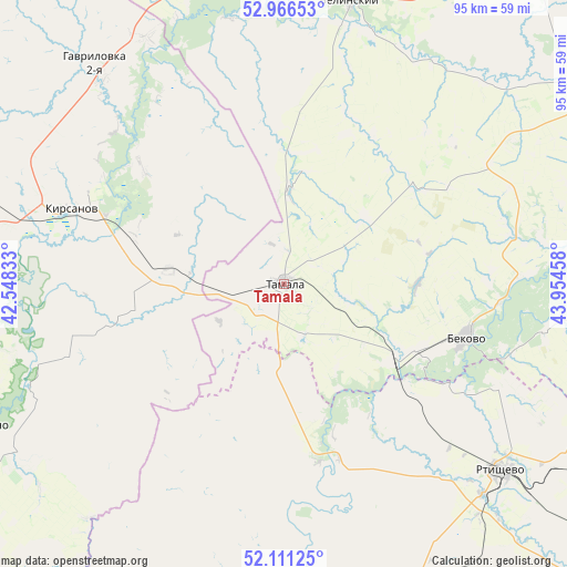
Tamala GPS coordinates[2]
52° 32' 27.492" North, 43° 15' 5.22" East
| Map corner | latitude | longitude |
|---|---|---|
| Upper-left | 52.96653°, | 42.54833° |
| Center: | 52.54097°, | 43.25145° |
| Lower-right: | 52.11125°, | 43.95458° |
| Map W x H: | 95.1×95.1 km | = 59.1×59.1mi |
| max Lat: | 73.50819° ⇑65.9% North |
| Tamala: | 52.54097° |
| min Lat: | ⇓34.1% South 41.28413° |
| min Long | Tamala | max Long |
| -179.12198° | 43.25145° | 179.35046° |
| W 44.4%⇐ | ⇒55.6% E |
Elevation
Elevation of Tamala is 207 m = 679 ft, and this is 4.4 m = 14 ft above average elevation for this country.
| Max E: |
2518 m = 8261 ft | 27.4% |
| Tamala | 207 m 679 ft | |
| Avg. | 202.6 m = 665 ft | |
Min E: |
-28 m = -92 ft | 72.6% |
See also: Russia elevation on elevation.city.
Geographical zone
Tamala is located in North temperate zone (between Tropic of Cancer and the Arctic Circle). Distance of this North polar circle is 1559.2 km =968.8 mi to North.| Distance of | km | miles | from Tamala |
|---|---|---|---|
| North Pole | 4165.1 | 2588.1 | to North |
| Arctic Circle | 1559.2 | 968.8 | to North |
| Tropic Cancer | 3236.1 | 2010.8 | to South |
| Equator | 5842 | 3630 | to South |


Nearby cities:
15 places around Tamala: (largest is in red/bold)
• Arkadak
69.7 km =43.3 mi,  166°
166°
• Bashmakovo
76.2 km =47.3 mi,  348°
348°
• Bekovo
32.3 km =20.1 mi,  104°
104°
• Belinskiy
48.4 km =30.1 mi,  13°
13°
• Gavrilovka Vtoraya
49.6 km =30.8 mi,  318°
318°
• Inzhavino
57 km =35.4 mi,  244°
244°
• Kirsanov
37.9 km =23.5 mi,  289°
289°
• Kolyshley
88.6 km =55.1 mi,  78°
78°
• Lermontovo
57.3 km =35.6 mi,  28°
28°
• Pachelma
78.5 km =48.8 mi,  4°
4°
• Platonovka
89.7 km =55.7 mi,  282°
282°
• Poim
54.1 km =33.6 mi,  355°
355°
• Rtishchevo
47.9 km =29.8 mi,  130°
130°
• Serdobsk
66 km =41 mi, 97°
• Turki
61.6 km =38.3 mi,  178°
178°
Sources, notices
• [Note1] Compared only with cities in Russia existing in our database
• [Src1] Map data: © OpenStreetMap contributors (CC-BY-SA)
• [Src2] Other city data from geonames.org with taken over terms of usage.
• [Src3] Geographical zone / Annual Mean Temperature by Robert A. Rohde @ Wikipedia
