Inzhavino geodata
Inzhavino (Tambov) is a populated place; located in Russia in Europe/Moscow (GMT+3) time zone. With population of 10,278 people, there are 1468 cities with bigger population in this country. Compared to other cities in Russia, 67.2% of cities are located further ↑North; 58.3% of cities are located further →East and 57.3% of cities have higher elevation than Inzhavino. Note1


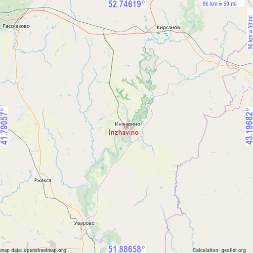
Inzhavino GPS coordinates[2]
52° 19' 6.492" North, 42° 29' 37.284" East
| Map corner | latitude | longitude |
|---|---|---|
| Upper-left | 52.74619°, | 41.79057° |
| Center: | 52.31847°, | 42.49369° |
| Lower-right: | 51.88658°, | 43.19682° |
| Map W x H: | 95.6×95.6 km | = 59.4×59.4mi |
| max Lat: | 73.50819° ⇑67.2% North |
| Inzhavino: | 52.31847° |
| min Lat: | ⇓32.8% South 41.28413° |
| min Long | Inzhavino | max Long |
| -179.12198° | 42.49369° | 179.35046° |
| W 41.7%⇐ | ⇒58.3% E |
Elevation
Elevation of Inzhavino is 130 m = 427 ft, and this is 72.6 m = 238 ft below average elevation for this country.
| Max E: |
2518 m = 8261 ft | 57.3% |
| Avg. | 202.6 m = 665 ft | |
| Inzhavino | 130 m = 427 ft | |
Min E: |
-28 m = -92 ft | 42.7% |
See also: Russia elevation on elevation.city.
Geographical zone
Inzhavino is located in North temperate zone (between Tropic of Cancer and the Arctic Circle). Distance of this North polar circle is 1583.9 km =984.2 mi to North.| Distance of | km | miles | from Inzhavino |
|---|---|---|---|
| North Pole | 4189.8 | 2603.4 | to North |
| Arctic Circle | 1583.9 | 984.2 | to North |
| Tropic Cancer | 3211.3 | 1995.4 | to South |
| Equator | 5817.3 | 3614.7 | to South |


Nearby cities:
15 places around Inzhavino: (largest is in red/bold)
• Bokino
78.5 km =48.8 mi,  296°
296°
• Gavrilovka Vtoraya
64.8 km =40.3 mi,  16°
16°
• Kirsanov
40.5 km =25.2 mi, 22°
• Kotovsk
73.5 km =45.7 mi,  293°
293°
• Muchkapskiy
52 km =32.3 mi,  181°
181°
• Novaya Lyada
72.6 km =45.1 mi,  307°
307°
• Platonovka
57 km =35.4 mi,  319°
319°
• Rasskazovo
55.8 km =34.7 mi, 312°
• Romanovka
66.3 km =41.2 mi,  164°
164°
• Rzhaksa
37.9 km =23.5 mi,  237°
237°
• Satinka
55.5 km =34.5 mi,  276°
276°
• Tamala
57 km =35.4 mi,  64°
64°
• Turki
64.7 km =40.2 mi,  124°
124°
• Uvarovo
40.3 km =25 mi,  203°
203°
• Znamenka
73 km =45.4 mi, 278°
Sources, notices
• [Note1] Compared only with cities in Russia existing in our database
• [Src1] Map data: © OpenStreetMap contributors (CC-BY-SA)
• [Src2] Other city data from geonames.org with taken over terms of usage.
• [Src3] Geographical zone / Annual Mean Temperature by Robert A. Rohde @ Wikipedia
