Staraya Poltavka geodata
Staraya Poltavka (Volgograd Oblast) is a populated place; located in Russia in Europe/Volgograd (GMT+3) time zone. With population of 4,068 people, there are 3073 cities with bigger population in this country. Compared to other cities in Russia, 76.7% of cities are located further ↑North; 54.1% of cities are located further ←West and 92.8% of cities have higher elevation than Staraya Poltavka. Note1


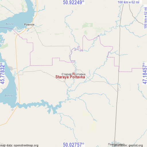
Staraya Poltavka GPS coordinates[2]
50° 28' 37.74" North, 46° 28' 53.184" East
| Map corner | latitude | longitude |
|---|---|---|
| Upper-left | 50.92249°, | 45.77832° |
| Center: | 50.47715°, | 46.48144° |
| Lower-right: | 50.02757°, | 47.18457° |
| Map W x H: | 99.5×99.5 km | = 61.8×61.8mi |
| max Lat: | 73.50819° ⇑76.7% North |
| Staraya Poltavka: | 50.47715° |
| min Lat: | ⇓23.3% South 41.28413° |
| min Long | Staraya Poltavk | max Long |
| -179.12198° | 46.48144° | 179.35046° |
| W 54.1%⇐ | ⇒45.9% E |
Elevation
Elevation of Staraya Poltavka is 19 m = 62 ft, and this is 183.6 m = 602 ft below average elevation for this country.
| Max E: |
2518 m = 8261 ft | 92.8% |
| Avg. | 202.6 m = 665 ft | |
| Staraya Poltavka | 19 m = 62 ft | |
Min E: |
-28 m = -92 ft | 7.2% |
See also: Russia elevation on elevation.city.
Geographical zone
Staraya Poltavka is located in North temperate zone (between Tropic of Cancer and the Arctic Circle). Distance of this North polar circle is 1788.6 km =1111.4 mi to North.| Distance of | km | miles | from Staraya Poltavka |
|---|---|---|---|
| North Pole | 4394.5 | 2730.6 | to North |
| Arctic Circle | 1788.6 | 1111.4 | to North |
| Tropic Cancer | 3006.6 | 1868.2 | to South |
| Equator | 5612.5 | 3487.4 | to South |


Nearby cities:
15 places around Staraya Poltavka: (largest is in red/bold)
• Antipovka
110.1 km =68.4 mi,  229°
229°
• Kamenskiy
83.4 km =51.8 mi,  302°
302°
• Kamyshin
86.6 km =53.8 mi,  240°
240°
• Krasnoarmeysk
82.1 km =51 mi,  317°
317°
• Krasnyy Kut
62.7 km =39 mi,  33°
33°
• Nikolayevsk
88.1 km =54.7 mi, 235°
• Pallasovka
55.4 km =34.4 mi,  148°
148°
• Petrov Val
97.6 km =60.6 mi,  247°
247°
• Piterka
71.7 km =44.6 mi,  71°
71°
• Privolzhskiy
108 km =67.1 mi,  343°
343°
• Pushkino
91.1 km =56.6 mi,  22°
22°
• Rovnoye
45.1 km =28 mi, 317°
• Savinka
62.4 km =38.8 mi,  135°
135°
• Sovetskoye
108.9 km =67.7 mi,  9°
9°
• Stepnoye
103.6 km =64.4 mi, 14°
Sources, notices
• [Note1] Compared only with cities in Russia existing in our database
• [Src1] Map data: © OpenStreetMap contributors (CC-BY-SA)
• [Src2] Other city data from geonames.org with taken over terms of usage.
• [Src3] Geographical zone / Annual Mean Temperature by Robert A. Rohde @ Wikipedia
