Rovnoye geodata
Rovnoye (Saratovskaya Oblast) is a populated place; located in Russia in Europe/Saratov (GMT+4) time zone. With population of 5,228 people, there are 2546 cities with bigger population in this country. Compared to other cities in Russia, 75.7% of cities are located further ↑North; 52.9% of cities are located further ←West and 92.5% of cities have higher elevation than Rovnoye. Note1


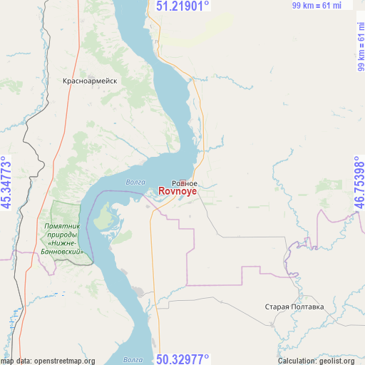
Rovnoye GPS coordinates[2]
50° 46' 35.4" North, 46° 3' 3.06" East
| Map corner | latitude | longitude |
|---|---|---|
| Upper-left | 51.21901°, | 45.34773° |
| Center: | 50.7765°, | 46.05085° |
| Lower-right: | 50.32977°, | 46.75398° |
| Map W x H: | 98.9×98.9 km | = 61.5×61.5mi |
| max Lat: | 73.50819° ⇑75.7% North |
| Rovnoye: | 50.7765° |
| min Lat: | ⇓24.3% South 41.28413° |
| min Long | Rovnoye | max Long |
| -179.12198° | 46.05085° | 179.35046° |
| W 52.9%⇐ | ⇒47.1% E |
Elevation
Elevation of Rovnoye is 20 m = 66 ft, and this is 182.6 m = 599 ft below average elevation for this country.
| Max E: |
2518 m = 8261 ft | 92.5% |
| Avg. | 202.6 m = 665 ft | |
| Rovnoye | 20 m = 66 ft | |
Min E: |
-28 m = -92 ft | 7.5% |
See also: Russia elevation on elevation.city.
Geographical zone
Rovnoye is located in North temperate zone (between Tropic of Cancer and the Arctic Circle). Distance of this North polar circle is 1755.4 km =1090.8 mi to North.| Distance of | km | miles | from Rovnoye |
|---|---|---|---|
| North Pole | 4361.2 | 2709.9 | to North |
| Arctic Circle | 1755.4 | 1090.8 | to North |
| Tropic Cancer | 3039.9 | 1888.9 | to South |
| Equator | 5645.8 | 3508.1 | to South |


Nearby cities:
15 places around Rovnoye: (largest is in red/bold)
• Engel’s
78.7 km =48.9 mi,  2°
2°
• Kamenskiy
41.3 km =25.7 mi,  287°
287°
• Kamyshin
87.8 km =54.6 mi,  210°
210°
• Krasnoarmeysk
37 km =23 mi,  317°
317°
• Krasnyy Kut
67.1 km =41.7 mi,  73°
73°
• Krasnyy Oktyabr’
88.3 km =54.9 mi,  344°
344°
• Petrov Val
92.2 km =57.3 mi,  220°
220°
• Privolzhskiy
70.4 km =43.7 mi,  359°
359°
• Pushkino
82.3 km =51.1 mi,  51°
51°
• Saratov
85 km =52.8 mi, 358°
• Shumeyka
88.6 km =55.1 mi,  8°
8°
• Sokolovyy
89.4 km =55.6 mi,  350°
350°
• Sovetskoye
88.4 km =54.9 mi,  33°
33°
• Staraya Poltavka
45.1 km =28 mi,  137°
137°
• Stepnoye
87.2 km =54.2 mi,  39°
39°
Sources, notices
• [Note1] Compared only with cities in Russia existing in our database
• [Src1] Map data: © OpenStreetMap contributors (CC-BY-SA)
• [Src2] Other city data from geonames.org with taken over terms of usage.
• [Src3] Geographical zone / Annual Mean Temperature by Robert A. Rohde @ Wikipedia
