Petrov Val geodata
Petrov Val (Volgograd Oblast) is a populated place; located in Russia in Europe/Volgograd (GMT+3) time zone. With population of 14,853 people, there are 1098 cities with bigger population in this country. Compared to other cities in Russia, 77.7% of cities are located further ↑North; 50.7% of cities are located further ←West and 67.7% of cities have higher elevation than Petrov Val. Note1


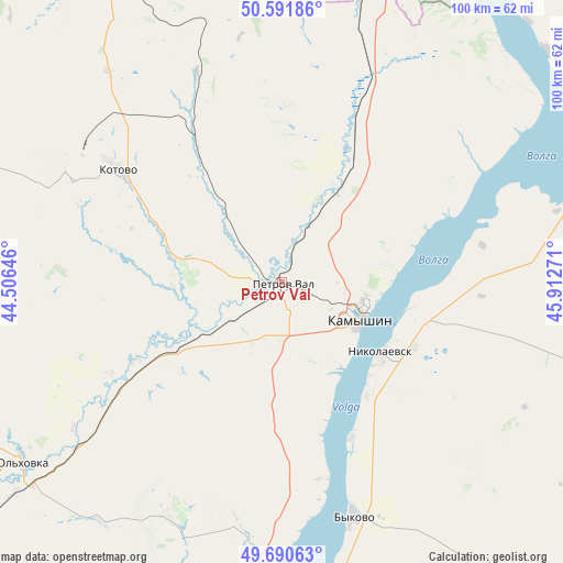
Petrov Val GPS coordinates[2]
50° 8' 36.132" North, 45° 12' 34.488" East
| Map corner | latitude | longitude |
|---|---|---|
| Upper-left | 50.59186°, | 44.50646° |
| Center: | 50.14337°, | 45.20958° |
| Lower-right: | 49.69063°, | 45.91271° |
| Map W x H: | 100.2×100.2 km | = 62.3×62.3mi |
| max Lat: | 73.50819° ⇑77.7% North |
| Petrov Val: | 50.14337° |
| min Lat: | ⇓22.3% South 41.28413° |
| min Long | Petrov Val | max Long |
| -179.12198° | 45.20958° | 179.35046° |
| W 50.7%⇐ | ⇒49.3% E |
Elevation
Elevation of Petrov Val is 108 m = 354 ft, and this is 94.6 m = 310 ft below average elevation for this country.
| Max E: |
2518 m = 8261 ft | 67.7% |
| Avg. | 202.6 m = 665 ft | |
| Petrov Val | 108 m = 354 ft | |
Min E: |
-28 m = -92 ft | 32.3% |
See also: Russia elevation on elevation.city.
Geographical zone
Petrov Val is located in North temperate zone (between Tropic of Cancer and the Arctic Circle). Distance of this North polar circle is 1825.8 km =1134.5 mi to North.| Distance of | km | miles | from Petrov Val |
|---|---|---|---|
| North Pole | 4431.6 | 2753.7 | to North |
| Arctic Circle | 1825.8 | 1134.5 | to North |
| Tropic Cancer | 2969.5 | 1845.2 | to South |
| Equator | 5575.4 | 3464.4 | to South |


Nearby cities:
15 places around Petrov Val: (largest is in red/bold)
• Antipovka
35.6 km =22.1 mi,  168°
168°
• Bykovo
43.9 km =27.3 mi,  163°
163°
• Danilovka
81.2 km =50.5 mi,  286°
286°
• Gornyy Balykley
66.8 km =41.5 mi,  188°
188°
• Kamenskiy
84.8 km =52.7 mi,  13°
13°
• Kamyshin
15.5 km =9.6 mi,  108°
108°
• Kotovo
35.1 km =21.8 mi,  304°
304°
• Krasnyy Yar
70.3 km =43.7 mi,  330°
330°
• Medveditskiy
79.6 km =49.5 mi, 333°
• Nikolayevsk
22 km =13.7 mi,  125°
125°
• Primorsk
98.5 km =61.2 mi, 187°
• Rovnoye
92.2 km =57.3 mi,  40°
40°
• Rudnya
86.2 km =53.6 mi, 327°
• Staraya Poltavka
97.6 km =60.6 mi,  67°
67°
• Zhirnovsk
98.5 km =61.2 mi,  341°
341°
Sources, notices
• [Note1] Compared only with cities in Russia existing in our database
• [Src1] Map data: © OpenStreetMap contributors (CC-BY-SA)
• [Src2] Other city data from geonames.org with taken over terms of usage.
• [Src3] Geographical zone / Annual Mean Temperature by Robert A. Rohde @ Wikipedia
