Sol’vychegodsk geodata
Sol’vychegodsk (Arkhangelskaya) is a populated place; located in Russia in Europe/Moscow (GMT+3) time zone. With population of 2,465 people, there are 3973 cities with bigger population in this country. Compared to other cities in Russia, 93.7% of cities are located further ↓South; 55.7% of cities are located further ←West and 80.3% of cities have higher elevation than Sol’vychegodsk. Note1


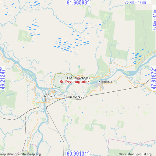
Sol’vychegodsk GPS coordinates[2]
61° 19' 49.656" North, 46° 54' 56.124" East
| Map corner | latitude | longitude |
|---|---|---|
| Upper-left | 61.66598°, | 46.21247° |
| Center: | 61.33046°, | 46.91559° |
| Lower-right: | 60.99131°, | 47.61872° |
| Map W x H: | 75×75 km | = 46.6×46.6mi |
| max Lat: | 73.50819° ⇑6.3% North |
| Sol’vychegodsk: | 61.33046° |
| min Lat: | ⇓93.7% South 41.28413° |
| min Long | Sol’vychegods | max Long |
| -179.12198° | 46.91559° | 179.35046° |
| W 55.7%⇐ | ⇒44.3% E |
Elevation
Elevation of Sol’vychegodsk is 70 m = 230 ft, and this is 132.6 m = 435 ft below average elevation for this country.
| Max E: |
2518 m = 8261 ft | 80.3% |
| Avg. | 202.6 m = 665 ft | |
| Sol’vychegodsk | 70 m = 230 ft | |
Min E: |
-28 m = -92 ft | 19.7% |
See also: Russia elevation on elevation.city.
Geographical zone
Sol’vychegodsk is located in North temperate zone (between Tropic of Cancer and the Arctic Circle). Distance of this North polar circle is 581.9 km =361.6 mi to North.| Distance of | km | miles | from Sol’vychegodsk |
|---|---|---|---|
| North Pole | 3187.8 | 1980.8 | to North |
| Arctic Circle | 581.9 | 361.6 | to North |
| Tropic Cancer | 4213.4 | 2618.1 | to South |
| Equator | 6819.3 | 4237.3 | to South |


Nearby cities:
15 places around Sol’vychegodsk: (largest is in red/bold)
• Cheremushskiy
19.6 km =12.2 mi,  108°
108°
• Il’insko-Podomskoye
61.8 km =38.4 mi, 112°
• Kharitonovo
32 km =19.9 mi,  75°
75°
• Khristoforovo
51.3 km =31.9 mi,  159°
159°
• Koryazhma
13.6 km =8.5 mi,  97°
97°
• Kotlas
16.4 km =10.2 mi,  240°
240°
• Krasavino
47.1 km =29.3 mi,  209°
209°
• Krasnoborsk
58.1 km =36.1 mi,  296°
296°
• Lal’sk
74.8 km =46.5 mi,  151°
151°
• Luza
79.9 km =49.6 mi,  166°
166°
• Privodino
35.9 km =22.3 mi,  218°
218°
• Shipitsyno
21.8 km =13.5 mi,  255°
255°
• Udimskiy
57.5 km =35.7 mi,  248°
248°
• Velikiy Ustyug
71 km =44.1 mi, 207°
• Vychegodskiy
9.3 km =5.8 mi,  185°
185°
Sources, notices
• [Note1] Compared only with cities in Russia existing in our database
• [Src1] Map data: © OpenStreetMap contributors (CC-BY-SA)
• [Src2] Other city data from geonames.org with taken over terms of usage.
• [Src3] Geographical zone / Annual Mean Temperature by Robert A. Rohde @ Wikipedia
