Mendeleyevo geodata
Mendeleyevo (Moscow Oblast) is a populated place; located in Russia in Europe/Moscow (GMT+3) time zone. With population of 7,964 people, there are 1809 cities with bigger population in this country. Compared to other cities in Russia, 67.1% of cities are located further ↓South; 83.9% of cities are located further →East and 74.5% of cities have lower elevation than Mendeleyevo. Note1


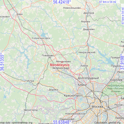
Mendeleyevo GPS coordinates[2]
56° 1' 59.988" North, 37° 13' 0.012" East
| Map corner | latitude | longitude |
|---|---|---|
| Upper-left | 56.42418°, | 36.51355° |
| Center: | 56.03333°, | 37.21667° |
| Lower-right: | 55.63848°, | 37.9198° |
| Map W x H: | 87.4×87.4 km | = 54.3×54.3mi |
| max Lat: | 73.50819° ⇑32.9% North |
| Mendeleyevo: | 56.03333° |
| min Lat: | ⇓67.1% South 41.28413° |
| min Long | Mendeleyevo | max Long |
| -179.12198° | 37.21667° | 179.35046° |
| W 16.1%⇐ | ⇒83.9% E |
Elevation
Elevation of Mendeleyevo is 214 m = 702 ft, and this is 11.4 m = 37 ft above average elevation for this country.
| Max E: |
2518 m = 8261 ft | 25.5% |
| Mendeleyevo | 214 m 702 ft | |
| Avg. | 202.6 m = 665 ft | |
Min E: |
-28 m = -92 ft | 74.5% |
See also: Russia elevation on elevation.city.
Geographical zone
Mendeleyevo is located in North temperate zone (between Tropic of Cancer and the Arctic Circle). Distance of this North polar circle is 1170.9 km =727.6 mi to North.| Distance of | km | miles | from Mendeleyevo |
|---|---|---|---|
| North Pole | 3776.7 | 2346.7 | to North |
| Arctic Circle | 1170.9 | 727.6 | to North |
| Tropic Cancer | 3624.4 | 2252.1 | to South |
| Equator | 6230.3 | 3871.3 | to South |


Nearby cities:
15 places around Mendeleyevo: (largest is in red/bold)
• Alabushevo
4.5 km =2.8 mi,  245°
245°
• Andreyevka
7.8 km =4.8 mi,  220°
220°
• Brëkhovo
11.2 km =7 mi,  188°
188°
• Chashnikovo
3.1 km =1.9 mi,  270°
270°
• Firsanovka
9 km =5.6 mi,  170°
170°
• Lobnya
16.7 km =10.4 mi,  99°
99°
• Lozhki
9.5 km =5.9 mi,  315°
315°
• Lugovaya
16.7 km =10.4 mi,  83°
83°
• Novopodrezkovo
13.1 km =8.1 mi,  142°
142°
• Peshki
14.5 km =9 mi, 320°
• Povarovo
11 km =6.8 mi,  289°
289°
• Radumlya
5.7 km =3.5 mi,  313°
313°
• Rzhavki
4.2 km =2.6 mi,  150°
150°
• Skhodnya
10.7 km =6.6 mi, 151°
• Zelenograd
6.1 km =3.8 mi,  201°
201°
Sources, notices
• [Note1] Compared only with cities in Russia existing in our database
• [Src1] Map data: © OpenStreetMap contributors (CC-BY-SA)
• [Src2] Other city data from geonames.org with taken over terms of usage.
• [Src3] Geographical zone / Annual Mean Temperature by Robert A. Rohde @ Wikipedia
