Zelenograd geodata
Zelenograd (Moscow) is a populated place; located in Russia in Europe/Moscow (GMT+3) time zone. With population of 215,727 people, there are 93 cities with bigger population in this country. Compared to other cities in Russia, 66.4% of cities are located further ↓South; 84.1% of cities are located further →East and 75.7% of cities have lower elevation than Zelenograd. Note1


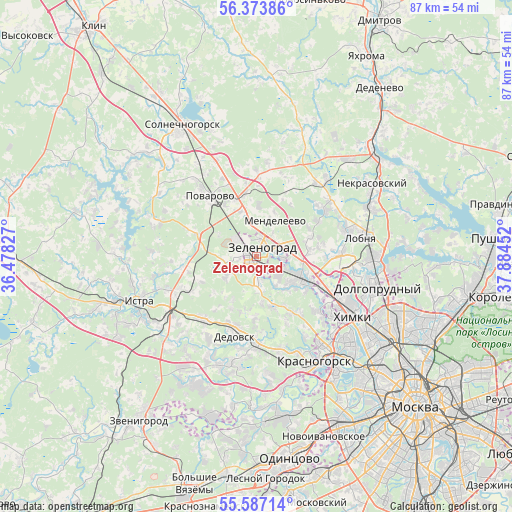
Zelenograd GPS coordinates[2]
55° 58' 57" North, 37° 10' 53.004" East
| Map corner | latitude | longitude |
|---|---|---|
| Upper-left | 56.37386°, | 36.47827° |
| Center: | 55.9825°, | 37.18139° |
| Lower-right: | 55.58714°, | 37.88452° |
| Map W x H: | 87.5×87.5 km | = 54.4×54.4mi |
| max Lat: | 73.50819° ⇑33.6% North |
| Zelenograd: | 55.9825° |
| min Lat: | ⇓66.4% South 41.28413° |
| min Long | Zelenograd | max Long |
| -179.12198° | 37.18139° | 179.35046° |
| W 15.9%⇐ | ⇒84.1% E |
Elevation
Elevation of Zelenograd is 220 m = 722 ft, and this is 17.4 m = 57 ft above average elevation for this country.
| Max E: |
2518 m = 8261 ft | 24.3% |
| Zelenograd | 220 m 722 ft | |
| Avg. | 202.6 m = 665 ft | |
Min E: |
-28 m = -92 ft | 75.7% |
See also: Zelenograd elevation on elevation.city.
Geographical zone
Zelenograd is located in North temperate zone (between Tropic of Cancer and the Arctic Circle). Distance of this North polar circle is 1176.5 km =731 mi to North.| Distance of | km | miles | from Zelenograd |
|---|---|---|---|
| North Pole | 3782.4 | 2350.3 | to North |
| Arctic Circle | 1176.5 | 731 | to North |
| Tropic Cancer | 3618.8 | 2248.6 | to South |
| Equator | 6224.7 | 3867.8 | to South |


Nearby cities:
15 places around Zelenograd: (largest is in red/bold)
• Alabushevo
4.3 km =2.7 mi,  332°
332°
• Andreyevka
2.9 km =1.8 mi,  265°
265°
• Brëkhovo
5.4 km =3.4 mi,  174°
174°
• Chashnikovo
5.7 km =3.5 mi,  350°
350°
• Dedovsk
13.2 km =8.2 mi,  196°
196°
• Firsanovka
4.9 km =3 mi,  130°
130°
• Lozhki
13.2 km =8.2 mi,  339°
339°
• Mendeleyevo
6.1 km =3.8 mi,  21°
21°
• Nakhabino
14.9 km =9.3 mi,  180°
180°
• Novopodrezkovo
11.2 km =7 mi,  115°
115°
• Povarovo
12.4 km =7.7 mi,  318°
318°
• Radumlya
9.8 km =6.1 mi, 348°
• Rzhavki
4.7 km =2.9 mi,  65°
65°
• Skhodnya
8.2 km =5.1 mi, 117°
• Snegiri
14.3 km =8.9 mi,  223°
223°
Sources, notices
• [Note1] Compared only with cities in Russia existing in our database
• [Src1] Map data: © OpenStreetMap contributors (CC-BY-SA)
• [Src2] Other city data from geonames.org with taken over terms of usage.
• [Src3] Geographical zone / Annual Mean Temperature by Robert A. Rohde @ Wikipedia
