Siukh geodata
Siukh (Dagestan) is a populated place; located in Russia in Europe/Moscow (GMT+3) time zone. With population of 3,425 people, there are 3454 cities with bigger population in this country. Compared to other cities in Russia, 98.7% of cities are located further ↑North; 54.3% of cities are located further ←West and 99.8% of cities have lower elevation than Siukh. Note1


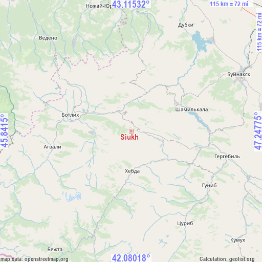
Siukh GPS coordinates[2]
42° 35' 59.64" North, 46° 32' 40.632" East
| Map corner | latitude | longitude |
|---|---|---|
| Upper-left | 43.11532°, | 45.8415° |
| Center: | 42.5999°, | 46.54462° |
| Lower-right: | 42.08018°, | 47.24775° |
| Map W x H: | 115.1×115.1 km | = 71.5×71.5mi |
| max Lat: | 73.50819° ⇑98.7% North |
| Siukh: | 42.5999° |
| min Lat: | ⇓1.3% South 41.28413° |
| min Long | Siukh | max Long |
| -179.12198° | 46.54462° | 179.35046° |
| W 54.3%⇐ | ⇒45.7% E |
Elevation
Elevation of Siukh is 1901 m = 6237 ft, and this is 1698.4 m = 5572 ft above average elevation for this country.
| Max E: |
2518 m = 8261 ft | 0.2% |
| Siukh | 1901 m 6237 ft | |
| Avg. | 202.6 m = 665 ft | |
Min E: |
-28 m = -92 ft | 99.8% |
See also: Russia elevation on elevation.city.
Geographical zone
Siukh is located in North temperate zone (between Tropic of Cancer and the Arctic Circle). Distance of this Northern Tropic circle is 2130.7 km =1324 mi to South.| Distance of | km | miles | from Siukh |
|---|---|---|---|
| North Pole | 5270.4 | 3274.9 | to North |
| Arctic Circle | 2664.5 | 1655.6 | to North |
| Tropic Cancer | 2130.7 | 1324 | to South |
| Equator | 4736.7 | 2943.2 | to South |


Nearby cities:
15 places around Siukh: (largest is in red/bold)
• Agvali
35.5 km =22.1 mi,  258°
258°
• Aknada
37.7 km =23.4 mi,  234°
234°
• Andi
30.9 km =19.2 mi,  311°
311°
• Ansalta
36.3 km =22.6 mi,  285°
285°
• Ashil’ta
24.3 km =15.1 mi,  38°
38°
• Erpeli
42.1 km =26.2 mi,  57°
57°
• Gagatli
30.5 km =19 mi,  317°
317°
• Gimry
30 km =18.6 mi,  53°
53°
• Gunib
41.8 km =26 mi,  124°
124°
• Irganay
30.5 km =19 mi,  80°
80°
• Karata
16.8 km =10.4 mi,  268°
268°
• Khebda
17.3 km =10.7 mi,  178°
178°
• Khunzakh
14.7 km =9.1 mi, 115°
• Shamil’kala
27.8 km =17.3 mi,  69°
69°
• Untsukul’
23.4 km =14.5 mi, 57°
Sources, notices
• [Note1] Compared only with cities in Russia existing in our database
• [Src1] Map data: © OpenStreetMap contributors (CC-BY-SA)
• [Src2] Other city data from geonames.org with taken over terms of usage.
• [Src3] Geographical zone / Annual Mean Temperature by Robert A. Rohde @ Wikipedia
