Agvali geodata
Agvali (Dagestan) is a populated place; located in Russia in Europe/Moscow (GMT+3) time zone. With population of 2,158 people, there are 4092 cities with bigger population in this country. Compared to other cities in Russia, 98.9% of cities are located further ↑North; 53.2% of cities are located further ←West and 98.5% of cities have lower elevation than Agvali. Note1


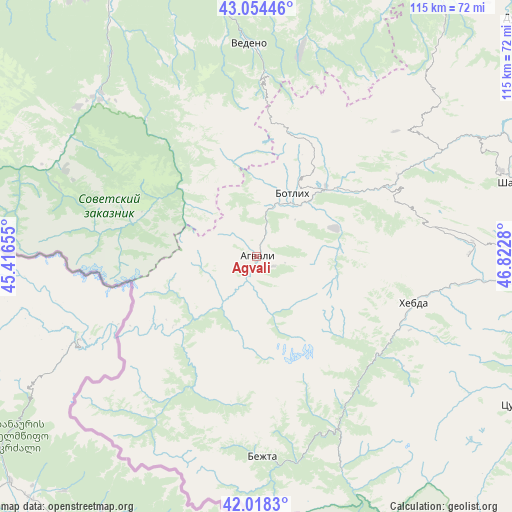
Agvali GPS coordinates[2]
42° 32' 18.708" North, 46° 7' 10.812" East
| Map corner | latitude | longitude |
|---|---|---|
| Upper-left | 43.05446°, | 45.41655° |
| Center: | 42.53853°, | 46.11967° |
| Lower-right: | 42.0183°, | 46.8228° |
| Map W x H: | 115.2×115.2 km | = 71.6×71.6mi |
| max Lat: | 73.50819° ⇑98.9% North |
| Agvali: | 42.53853° |
| min Lat: | ⇓1.1% South 41.28413° |
| min Long | Agvali | max Long |
| -179.12198° | 46.11967° | 179.35046° |
| W 53.2%⇐ | ⇒46.8% E |
Elevation
Elevation of Agvali is 975 m = 3199 ft, and this is 772.4 m = 2534 ft above average elevation for this country.
| Max E: |
2518 m = 8261 ft | 1.5% |
| Agvali | 975 m 3199 ft | |
| Avg. | 202.6 m = 665 ft | |
Min E: |
-28 m = -92 ft | 98.5% |
See also: Russia elevation on elevation.city.
Geographical zone
Agvali is located in North temperate zone (between Tropic of Cancer and the Arctic Circle). Distance of this Northern Tropic circle is 2123.9 km =1319.7 mi to South.| Distance of | km | miles | from Agvali |
|---|---|---|---|
| North Pole | 5277.2 | 3279.1 | to North |
| Arctic Circle | 2671.3 | 1659.9 | to North |
| Tropic Cancer | 2123.9 | 1319.7 | to South |
| Equator | 4729.8 | 2939 | to South |


Nearby cities:
15 places around Agvali: (largest is in red/bold)
• Aknada
15.8 km =9.8 mi,  164°
164°
• Andi
29.6 km =18.4 mi,  23°
23°
• Ansalta
16.8 km =10.4 mi,  359°
359°
• Bezhta
45 km =28 mi,  179°
179°
• Dyshne-Vedeno
47.3 km =29.4 mi, 359°
• Gagatli
32.4 km =20.1 mi,  25°
25°
• Itum-Kali
49.6 km =30.8 mi,  296°
296°
• Karata
19 km =11.8 mi,  70°
70°
• Khebda
36.9 km =22.9 mi,  106°
106°
• Khunzakh
48.1 km =29.9 mi,  89°
89°
• Kidero
40.6 km =25.2 mi,  199°
199°
• Shatoy
51.1 km =31.8 mi,  316°
316°
• Siukh
35.5 km =22.1 mi,  78°
78°
• Tlyarata
52.1 km =32.4 mi, 158°
• Vedeno
47.9 km =29.8 mi, 357°
Sources, notices
• [Note1] Compared only with cities in Russia existing in our database
• [Src1] Map data: © OpenStreetMap contributors (CC-BY-SA)
• [Src2] Other city data from geonames.org with taken over terms of usage.
• [Src3] Geographical zone / Annual Mean Temperature by Robert A. Rohde @ Wikipedia
