Shamil’kala geodata
Shamil’kala (Dagestan) is a populated place; located in Russia in Europe/Moscow (GMT+3) time zone. With population of 7,163 people, there are 1962 cities with bigger population in this country. Compared to other cities in Russia, 98.6% of cities are located further ↑North; 55.6% of cities are located further ←West and 94.1% of cities have lower elevation than Shamil’kala. Note1


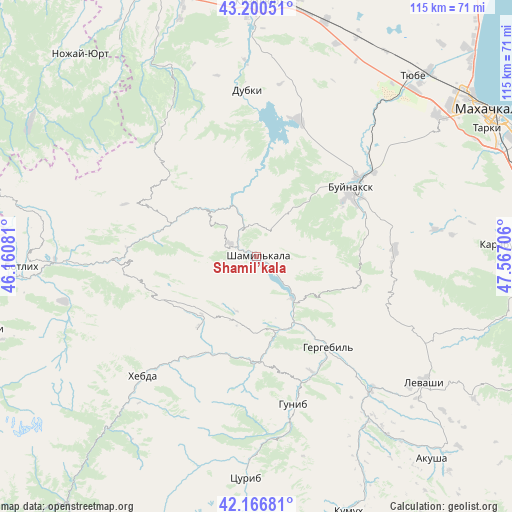
Shamil’kala GPS coordinates[2]
42° 41' 8.916" North, 46° 51' 50.148" East
| Map corner | latitude | longitude |
|---|---|---|
| Upper-left | 43.20051°, | 46.16081° |
| Center: | 42.68581°, | 46.86393° |
| Lower-right: | 42.16681°, | 47.56706° |
| Map W x H: | 114.9×114.9 km | = 71.4×71.4mi |
| max Lat: | 73.50819° ⇑98.6% North |
| Shamil’kala: | 42.68581° |
| min Lat: | ⇓1.4% South 41.28413° |
| min Long | Shamil’kala | max Long |
| -179.12198° | 46.86393° | 179.35046° |
| W 55.6%⇐ | ⇒44.4% E |
Elevation
Elevation of Shamil’kala is 589 m = 1932 ft, and this is 386.4 m = 1268 ft above average elevation for this country.
| Max E: |
2518 m = 8261 ft | 5.9% |
| Shamil’kala | 589 m 1932 ft | |
| Avg. | 202.6 m = 665 ft | |
Min E: |
-28 m = -92 ft | 94.1% |
See also: Russia elevation on elevation.city.
Geographical zone
Shamil’kala is located in North temperate zone (between Tropic of Cancer and the Arctic Circle). Distance of this Northern Tropic circle is 2140.3 km =1329.9 mi to South.| Distance of | km | miles | from Shamil’kala |
|---|---|---|---|
| North Pole | 5260.8 | 3268.9 | to North |
| Arctic Circle | 2655 | 1649.7 | to North |
| Tropic Cancer | 2140.3 | 1329.9 | to South |
| Equator | 4746.2 | 2949.2 | to South |


Nearby cities:
15 places around Shamil’kala: (largest is in red/bold)
• Ashil’ta
14.4 km =8.9 mi,  310°
310°
• Buynaksk
25.6 km =15.9 mi,  54°
54°
• Chirkey
32 km =19.9 mi,  16°
16°
• Erpeli
16.2 km =10.1 mi,  34°
34°
• Gergebil’
26.1 km =16.2 mi,  140°
140°
• Gimry
8.5 km =5.3 mi,  346°
346°
• Irganay
5.9 km =3.7 mi, 138°
• Kafyr-Kumukh
29.1 km =18.1 mi, 54°
• Karamakhi
33.2 km =20.6 mi,  102°
102°
• Khunzakh
20.5 km =12.7 mi,  218°
218°
• Nizhneye Kazanishche
25.7 km =16 mi,  70°
70°
• Nizhniy Dzhengutay
31.2 km =19.4 mi,  87°
87°
• Siukh
27.8 km =17.3 mi,  249°
249°
• Untsukul’
6.9 km =4.3 mi,  294°
294°
• Verkhneye Kazanishche
23 km =14.3 mi,  76°
76°
Sources, notices
• [Note1] Compared only with cities in Russia existing in our database
• [Src1] Map data: © OpenStreetMap contributors (CC-BY-SA)
• [Src2] Other city data from geonames.org with taken over terms of usage.
• [Src3] Geographical zone / Annual Mean Temperature by Robert A. Rohde @ Wikipedia
