Khebda geodata
Khebda (Dagestan) is a populated place; located in Russia in Europe/Moscow (GMT+3) time zone. With population of 2,749 people, there are 3874 cities with bigger population in this country. Compared to other cities in Russia, 98.9% of cities are located further ↑North; 54.4% of cities are located further ←West and 98.2% of cities have lower elevation than Khebda. Note1


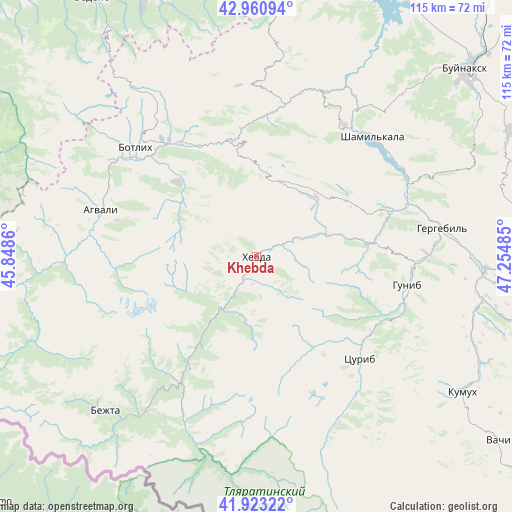
Khebda GPS coordinates[2]
42° 26' 39.228" North, 46° 33' 6.192" East
| Map corner | latitude | longitude |
|---|---|---|
| Upper-left | 42.96094°, | 45.8486° |
| Center: | 42.44423°, | 46.55172° |
| Lower-right: | 41.92322°, | 47.25485° |
| Map W x H: | 115.4×115.4 km | = 71.7×71.7mi |
| max Lat: | 73.50819° ⇑98.9% North |
| Khebda: | 42.44423° |
| min Lat: | ⇓1.1% South 41.28413° |
| min Long | Khebda | max Long |
| -179.12198° | 46.55172° | 179.35046° |
| W 54.4%⇐ | ⇒45.6% E |
Elevation
Elevation of Khebda is 904 m = 2966 ft, and this is 701.4 m = 2301 ft above average elevation for this country.
| Max E: |
2518 m = 8261 ft | 1.8% |
| Khebda | 904 m 2966 ft | |
| Avg. | 202.6 m = 665 ft | |
Min E: |
-28 m = -92 ft | 98.2% |
See also: Russia elevation on elevation.city.
Geographical zone
Khebda is located in North temperate zone (between Tropic of Cancer and the Arctic Circle). Distance of this Northern Tropic circle is 2113.4 km =1313.2 mi to South.| Distance of | km | miles | from Khebda |
|---|---|---|---|
| North Pole | 5287.7 | 3285.6 | to North |
| Arctic Circle | 2681.8 | 1666.4 | to North |
| Tropic Cancer | 2113.4 | 1313.2 | to South |
| Equator | 4719.4 | 2932.5 | to South |


Nearby cities:
15 places around Khebda: (largest is in red/bold)
• Agvali
36.9 km =22.9 mi,  286°
286°
• Aknada
31.5 km =19.6 mi,  261°
261°
• Andi
44.6 km =27.7 mi,  327°
327°
• Ashil’ta
39.1 km =24.3 mi,  21°
21°
• Gergebil’
42.7 km =26.5 mi,  80°
80°
• Gimry
42.3 km =26.3 mi,  33°
33°
• Gunib
34.5 km =21.4 mi,  100°
100°
• Irganay
37.1 km =23.1 mi,  52°
52°
• Karata
24.2 km =15 mi,  313°
313°
• Khunzakh
16.8 km =10.4 mi, 49°
• Shamil’kala
37.1 km =23.1 mi,  43°
43°
• Siukh
17.3 km =10.7 mi,  358°
358°
• Tlyarata
41.1 km =25.5 mi,  203°
203°
• Tsurib
32.5 km =20.2 mi,  135°
135°
• Untsukul’
35.4 km =22 mi, 32°
Sources, notices
• [Note1] Compared only with cities in Russia existing in our database
• [Src1] Map data: © OpenStreetMap contributors (CC-BY-SA)
• [Src2] Other city data from geonames.org with taken over terms of usage.
• [Src3] Geographical zone / Annual Mean Temperature by Robert A. Rohde @ Wikipedia
