Untsukul’ geodata
Untsukul’ (Dagestan) is a populated place; located in Russia in Europe/Moscow (GMT+3) time zone. With population of 5,913 people, there are 2291 cities with bigger population in this country. Compared to other cities in Russia, 98.5% of cities are located further ↑North; 55.2% of cities are located further ←West and 98% of cities have lower elevation than Untsukul’. Note1


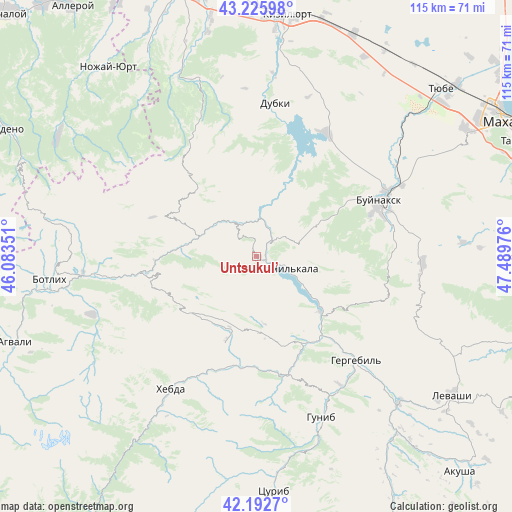
Untsukul’ GPS coordinates[2]
42° 42' 41.364" North, 46° 47' 11.868" East
| Map corner | latitude | longitude |
|---|---|---|
| Upper-left | 43.22598°, | 46.08351° |
| Center: | 42.71149°, | 46.78663° |
| Lower-right: | 42.1927°, | 47.48976° |
| Map W x H: | 114.9×114.9 km | = 71.4×71.4mi |
| max Lat: | 73.50819° ⇑98.5% North |
| Untsukul’: | 42.71149° |
| min Lat: | ⇓1.5% South 41.28413° |
| min Long | Untsukul’ | max Long |
| -179.12198° | 46.78663° | 179.35046° |
| W 55.2%⇐ | ⇒44.8% E |
Elevation
Elevation of Untsukul’ is 874 m = 2867 ft, and this is 671.4 m = 2203 ft above average elevation for this country.
| Max E: |
2518 m = 8261 ft | 2% |
| Untsukul’ | 874 m 2867 ft | |
| Avg. | 202.6 m = 665 ft | |
Min E: |
-28 m = -92 ft | 98% |
See also: Russia elevation on elevation.city.
Geographical zone
Untsukul’ is located in North temperate zone (between Tropic of Cancer and the Arctic Circle). Distance of this Northern Tropic circle is 2143.2 km =1331.7 mi to South.| Distance of | km | miles | from Untsukul’ |
|---|---|---|---|
| North Pole | 5258 | 3267.2 | to North |
| Arctic Circle | 2652.1 | 1647.9 | to North |
| Tropic Cancer | 2143.2 | 1331.7 | to South |
| Equator | 4749.1 | 2951 | to South |


Nearby cities:
15 places around Untsukul’: (largest is in red/bold)
• Ashil’ta
8 km =5 mi,  324°
324°
• Burtunay
33.3 km =20.7 mi,  337°
337°
• Buynaksk
29.7 km =18.5 mi,  66°
66°
• Chirkey
31.9 km =19.8 mi,  29°
29°
• Dubki
34.7 km =21.6 mi,  6°
6°
• Erpeli
18.8 km =11.7 mi,  56°
56°
• Gergebil’
32.4 km =20.1 mi,  135°
135°
• Gimry
6.9 km =4.3 mi,  38°
38°
• Irganay
12.5 km =7.8 mi,  125°
125°
• Kafyr-Kumukh
33.1 km =20.6 mi, 64°
• Khunzakh
19.9 km =12.4 mi,  199°
199°
• Nizhneye Kazanishche
31.1 km =19.3 mi,  79°
79°
• Shamil’kala
6.9 km =4.3 mi,  114°
114°
• Siukh
23.4 km =14.5 mi,  237°
237°
• Verkhneye Kazanishche
28.8 km =17.9 mi, 84°
Sources, notices
• [Note1] Compared only with cities in Russia existing in our database
• [Src1] Map data: © OpenStreetMap contributors (CC-BY-SA)
• [Src2] Other city data from geonames.org with taken over terms of usage.
• [Src3] Geographical zone / Annual Mean Temperature by Robert A. Rohde @ Wikipedia
